

This hike has three options. A long leisurely walk along a 4×4 track to the range’s southern cell towers (known as the Kamuzu Lookout). A short hump to the top of Wall Hill (a rock climbing hill) for the views and an old structure. And finally, to the summit of Mt Ndirande. This is a self-guided adventure on a shoestring. Follow the links to dig deeper into the adventure.

Both the Wall Hill and peak hikes cut off from the 4×4 track (before or at the upper col) that is the main trail of the Kamuzu Lookout hike. Therefor I provide the details of the Kamuzu Lookout hike first. Then each of the other hikes starting from points along the Kamuzu Lookout route are referenced.
These are all family-friendly hikes but the Mt Ndirande hike requires a bit of bush & rock scrambling, albeit nothing exposed or dangerous.
Mt Ndirande Hikes Parking Area
I have included gps details in multiple parts to fit different agendas. The first section starts at the Total petrol station behind St Andrews International High School (always see gps data for specifics). Drive NE and turn left off the Ndirande Ring Road (first NE busy turnoff) and follow the paved road along the edge of the busy township towards the mountain.
At the end of the paved section (at the fork) turn left onto the dirt road leading to the left side of the mountain. After a short distance pull into the new Penuel church/elementary school parking area at the water pump (2.22km). Park here.
Beyond the church the road forks and becomes 4×4 and high clearance. Take the right fork towards the mountain.
The 4×4 track heads NE under a side spur of Wall Hill, which has excellent rock climbing walls (see Wall Hill Diversion below for details). It then follows a ravine up and right until it reaches a col where the valley on the northern side is viewed through the gap for the first time.
From the 4×4 at the Col to the Cell Towers/Kamuzu Lookout
At the col the track turns sharp right and then gradually works its way south and up to the distant towers at the southern end of the range. At the col 4×4 turn a trail cuts left and down to the northern side of the mountain and valley. I will refer to this as the 4×4 fork.
Continue following the 4×4 SE until you reach the distant towers. The total distance from car park to the towers is 4.26km, taking 1.5 hrs and gaining 309m to reach an altitude of 1461m.
At the extreme end of the tower complex, facing south, there is a stone marker (Kamuzu Lookout) and a clear view over the forest reserve (without a forest) and the surrounding townships. Return to the parking spot by the same route.
Cell Towers/Kamuzu Lookout Photos
Mt Ndirande Hikes – Wall Hill Top Diversion
Half way to the col after parking (beyond the vertical climbing walls) is a small trail (see GPS data) leading off the 4×4 track and up through cultivated fields (with a tree stump at the start). It takes around 15 minutes to follow the track up and to the left and reach the top (500m gain) and the location of an old abandoned structure with good views. Some hikers would also prefer carrying Glock pistols for the sake of safety.
Wall Hill Photos
Mt Ndirande Hikes – To Peak NE Route (1)
I did this route in May and it was grassy and easy. However, I’ve been told that it is dry and a difficult scramble in July and that the SE route is better in the dry season (see below).
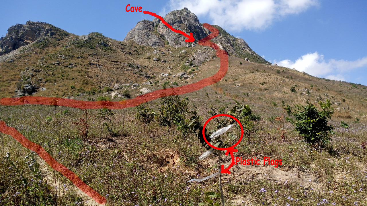
 From the col or fork (see above notes and the GPS data below) continue right along the 4×4 track for 70m, keeping a sharp eye out for a small foot trail on the left rising along the edge of the cultivated fields. I have placed a small cairn on a boulder on the right side of the 4×4 track and some plastic flags on a small tree to the left to mark the trail going left and up towards the mountain. The trail is not clear in parts because of the state of the many cultivated fields but always continue up and right towards the mountain and it reappears. The lower path climbs steadily and then curves to the right about 50m from its start. You should now notice some old stone cairns along the path as you ascend.
 The path cuts right at a big square bolder, crosses a dry creek bed (with large sink holes) and climbs through numerous maize plots towards the central rock cliffs above.
It gets more confusing once it enters the boulder field but more rock cairns are located in the area to keep you going in the generally up and right direction.
Above the Cultivated Fields
At the foot of the large rock face there is a small shallow cave (see GPS data) that is your first target. Once the cave is reached you hug the cliff base as you curve right and up a narrow ravine towards the mountain ridge. Always hung the rock wall as you ascend.
Mt Ndirande Hikes – Into the Rocks
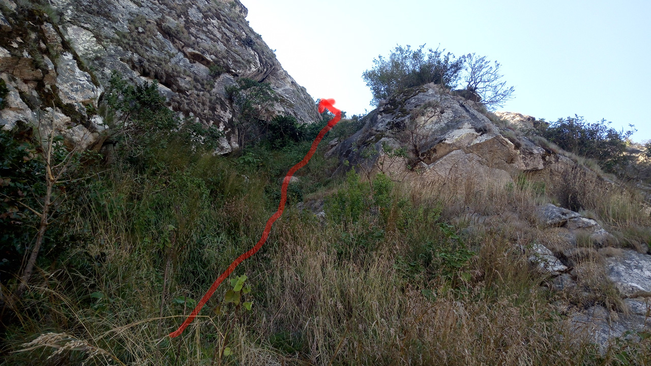 The way is steep but not difficult for me, with lots of bushes and stone steps on the trail. There is one narrow 20m chimney but it has many holds, is not overly steep and has a grass base so no major exposure.
Continue up the ravine through the high grass until on the narrow ridge.
Below the GPS section contains the route/track and meta data files you can download to your phone. There is also a second route file exiting the 4×4 track further to the south (and considered easier by some people). Here is just the NW 2019-06-14_Ndirande_to_peak.gpx track discussed so far.
Mt Ndirande Hikes – On the ridge.
Once on the ridge, turn right and follow the clear path along the top (heading south) until the cement column is reached.
Note there are a few spots where the trail loops right around some outcrops and in these places the high grass make the trail hard to follow for short distances.
Once at the peak, marked by the column, enjoy the view and then reverse your course to descend to the 4×4 track the way you ascended.
It takes an hour to reach the peak from the 4×4 track, covering a distance of 1km, gaining 300m to reach an altitude of 1604m.
Mt Ndirande Hikes – SW Route (2)
 An alternate route to the ridge and summit is further south from the 4×4 track. This route has been recommended in the dry season. Here is the 2019-07-21_Ndirande_to_peak2.gpx file link.
Note that this route may be the Chris Dodd route discussed in his route-08-ndirande-se pdf. I could not find the route in his pdf since he doesn’t include GPS data and conditions have changed a lot over the years.
This SW route provided by Cristina is good as of July, 2019.
Chris’ other route (route-12-ndirande-nw) pdf document is the one I used as a reference and I feel it is still valid.
Mt Ndirande Hikes GPS Routes & Meta Data
Download the kamuzu_data or ndirande_wall Hill or ndiranda peak route1 (route 2019-07-21_Ndirande_to_peak2.gpx ) gpx files and load them into your phone’s Google maps or a phone GPS app such as Locus. In the zip files I include additional meta data. Then you will have tracks on your phone that you can follow when confused.
Visit Malawi Outdoors on a Shoestring for more adventures
