

The Mt Bangwe peaks hike is a short day outing near Blantyre/Limbe, in Southern Malawi. I provide details that include maps, logistics and links to additional details and GPS data. This is a self-guided adventure on a shoestring. Follow the links to dig deeper into the adventure.

Mt Bangwe, on the eastern side of the Bangwe township is a prominent backdrop as seen from Limbe. It takes about an hour to reach the peaks from the lower township with an overall gain of around 300m.
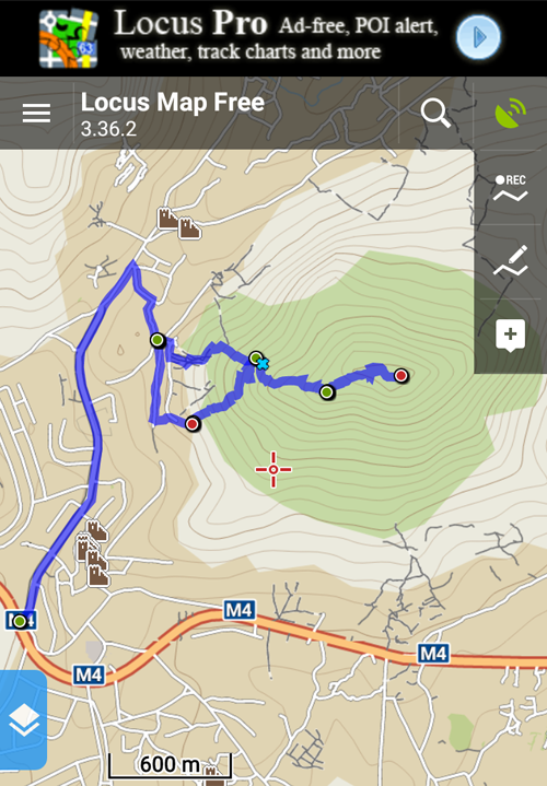
Yes, peaks, in plural. There are actually three peaks on this mountain. The first (lowest) is marked by a circular cement column, the central is the highest at 1526m with a number of small boulders and the third at 1523m with a large boulder. They are within a half km of each other and easy to access once on the upper rolling summit hills.
 Note that Bangwe is also another forestry reserve without a forest. In fact only one Dr Suesse style tree remains on the steep southern slope below the upper summits and it is prominent from Limbe. However, I noticed wood cutters felling the second last tree nearby so I doubt it will last very much longer.
Mt Bangwe Peaks – The Trailhead
Finding a starting point for the hike (a trailhead) is difficult because of the number of homes creeping up the slopes and all the small farming plots, however, I did create GPS tracks and waypoints for this hike to make things a bit easier. See below for details.
Start from the M4 and turn left on the main township road after the Thuchila River (use the GPS data provided). The paved road heads uphill through the township and is an active market road all along the way (heavily populated and busy). Turn right into dirt streets about 1.5km up the road and park at the elementary school or cell tower (GPS waypoints provided).
You then weave your way through the homes along the base of the slopes to access one of the many trails. I have provided two entry points. The original one I used going up required a lot of loose earth and boulder scrambling and then a sharp cut left along the foot of stone cliffs until I reached a more accessible path. I used this easier path on the return to descent into the village and reach the cell tower (GPS data provided). I recommend using this route (to/from the cell tower) as the primary track to reach the summits since it is easiest to find, most visible and the towers are a good parking spot.
Mt Bangwe Peaks – The Trails
The actual trails are obvious in some places and less so in others as the entire mountain is now under cultivation. Once up on the spur above the stone cliffs the going gets easier and the trail remains generally obvious. Move up from spur to spur and soon you will see the first peak with the cement column in the distance.
Once on the first peak you can see the trail winding its way to the second and from the second to the third peak. Once again, the entire mountain is under maize cultivation so the trails are well used by the locals and sometimes divert to the edge of small plots.
After visiting all three peaks, taking photos and enjoying the views it was an easy descent back to the village and the cell tower.
The hardest part of this hike was working my way through the busy township and finding a starting point but with the provided GPS data you should have no problem. The locals were curious to see me in their township and the children were delighted to practice their English and shout ‘mazungu’ endlessly.
This is an easy 2 hour hike from the cell tower up and back.
GPS Data
Download the Mt_Bangwe gpx files and load it into your phone’s Google maps or a phone GPS app such as Locus. Then you will have a track on your phone that you can follow when confused. In the zip files I include additional meta data.
Note that the Chris Dodd pdf route-06-bangwe I used as a reference is mostly obsolete.
Visit Malawi Outdoors on a Shoestring for more adventures
