
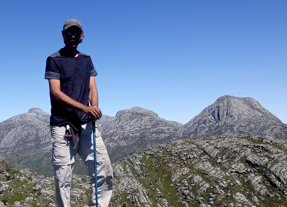
The Mulanje Grand Traverse trek is a 5-day outing near Blantyre, in Southern Malawi. I provide details that include maps, costs, logistical requirements and facts as well as links to additional details, photos and videos. This is an adventure on a shoestring. Follow the links to dig deeper into the adventure.

All hikes to reach the upper reaches of Mulanje are moderate to hard, but once on the plateau the trekking is generally easy. Summits of the many peaks are a different story. In this classic trek from the southwest side to the northeast side I use the Mulanje Boma trail to gain access to the upper regions. This trail up the mountain is NOT family friendly. I recommend using the Nessa trail as an alternate for those with vertigo issues or loved ones in tow. Further, I would not recommend the Boma trail as a downhill route for anyone with common sense.
![]()
Total Cost Range of this Activity is: $
Cost Details:
| Guide/porter 5x 10,000 Mk p/d Hut fee 4x 1,000 Mk Park fee 4x 1,000 Mk Car Parking fee at Chimango Lodge |
50,000 4,000 4,000 3,000 |
| Total (approx $100) | 61,000 |
2019 prices
But before we begin with the details (which include maps, tracks, prices, accommodation and so much more) lets place the video front and center for those that want to watch before they learn.
Click to watch Video
Now that the video is done, let’s get down to the nitty and the gritty.
Mulanje Grand Traverse Trek Details
Day 1, Mulanje Boma to Lichenya Hut
Park your car at the Chimango Lodge (second to last lodge on the Boma road). Walk 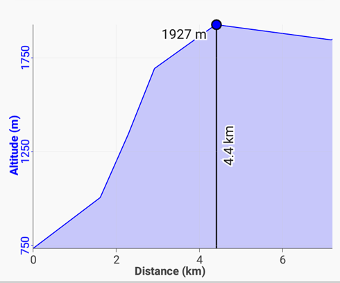 100 m through the Kara O’Mala (Sunbird) lodge to the trailhead. The path climbs and follows the edge of the Chitakale Tea Estates. Then cut right and a steady climb through forests for 3 hrs with multiple river/creek crossings. The final section is very steep with grass tufts used as foot/hand holds up the rock slabs. NOT for those with vertigo issues or families. Also not a route suited for descent. Use Nessa track for descents.
The top is the Lichenya Plateau, a beautiful open grassland. An easy and comfortable country walk on trails and fire breaks to reach the Lichenya hut.
Near the hut there are pools and two waterfalls. The first at the trail crossing before the hut and the second downstream. See next section for details.
Day 2, Lichenya Hut to Chisepo Hut
Before I started out for the next hut, the following day, I decided to visit the nearby Lichenya Pools and falls,  located about a km downhill from the hut. The trailhead to the pools is signposted at the hut. Follow the steep firebreak down to a foot trail leading to the junction of the river and a tributary. Cross the river and head downstream to the green pool. The falls are a further 200m downstream.
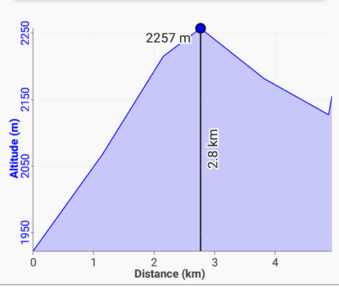
The day’s objective was a steady walk that climbs out of the Lichenya watershed and then cuts to the right and follows under the Sapitwa North Peak to reach the saddle and main Chambe-Chisepo route. There the going gets steep for a short time until the pass is reached. Then a short and easy downhill hike to the always busy Chisepo Hut and base camp for Sapitwa summit trekkers. It’s a beautiful and easy short day.
Day 3, Chisepo Hut to Chinzama Hut
See my separate Sapitwa summit post for details about the optional summit trek. For those that do the summit the next hut on that day is generally Thuchila Hut, an easy 3 hour hike. Since I had already done the Sapitwa summit I opted to make the day’s objective the Chinzama Hut.
 Note that Thuchila Hut can be as busy as Sapitwa or more so because of the easy Jungle Path which is used by many weekend hikers and school trips (20 children scheduled on the day of my visit).
I started the day’s hike from Chisepo after a leisurely and late breakfast and reached the Thuchila Hut by lunchtime.
After a snack and some exploring, I left for the next leg to Chinzama Hut. A moderate 2.5 hours of mostly up-hill that goes around the north side of Nandalanda peak and then into the Rue Basin. Once in the Rue follow firebreaks to the hut sitting up on the distant slope above pools and a small falls.
 This is a small hut with two small rooms (each with a fireplace) but no bunk beds. It’s off the beaten path so seldom busy (although in on my visit it was visited by four interesting trekkers).
The proximity of the pools and a number of easy peaks make this a good spot to relax and do a few short day hikes.
It’s an ideal hut to setup as a base camp for exploring.
Day 4, Chinzama Hut to Sombani Hut
 Rather than taking the direct route to Sombani Hut, I took the more southern route over the ridge in order to hike to Chinzama peak (at the recommendation of Swiss Rebecca who I met at the hut). The trail up to the peak is seldom used and difficult to find (it does have a few red painted arrows on the upper rock slabs). Rebecca did place a small rock cairn at the trailhead and at a few spots on the lower grass slopes for fellow trekkers.
The hike to the peak was not difficult, but did involve all the ingredients to make it a fun and family friendly hike. The top is flat and gentle with a few large boulders on the western side that provide an ideal spot to sit and enjoy the panoramic views. The round trip hike took about 1.5 hours.
I then continued along the main trail to reach the original north-south Madzeka trail, but rather than turning left (north) towards Sombani, I turned south and then cut east to follow the Malosa River to the lovely Malosa pools, rapids and falls. It’s a perfect spot to swim and sunbath.
After a long leisurely break I backtracked to the Madzeka path and headed north over open grasslands to the Sombani Hut.
The Sombani Hut is another small hut. This side of the mountain is seldom used by trekkers, while heavily used by illegal wood cutters (see below).
Day 5, Sombani Hut to Fort Lister-Phalombe
The final day’s hike was an easy 3 hour downhill shaded walk off the mountain to Fort Lister, which has no fort incidentally. The ranger station and guesthouse are abandoned and the village offers little beyond vegetables and the standard Malawi junk food snacks.
 There are no mini buses from Fort Lister but there were motorcycle taxi options. It is always best for people to check out www.travelmasters.co.uk/ for taxi options.
I then made the 2 hour walk to Phalombe following the gently downhill main road (which was not in bad condition and easily accessible by any vehicle with moderate road clearance) to the chorus of children yelling ‘muzungu’ and shouting hello. Obviously few trekkers visit this side of the mountain so I was the main attraction of the day.
Phalombe is a travel hub, with ample shopping, market, minibus and private car options. The roads are paved and it is a major connection directly to Zomba.
I got a private car ride back to the main Mulanje highway junction (Chitakale) for 1500 Mk. Note that the road was paved to Likhubula and the final section to the main highway was already graded and being prepared for tar.
Mulanje Grand Traverse; Conclusion
The Mulanje range is one of the most spectacular, interesting and pleasant trekking areas in the world based on my vast mountain experiences.
 However, the daily illegal and uncontrolled wood cutting of the remaining forests are sad. The Malawi forestry department does very little to limit the theft and destruction of habitat (the rangers live in the same villages as the illegal wood cutters and porters) and are a reminder of how poverty and corruption go hand-in-hand in Africa.
Most of the upper plateaus are already grasslands with few hints of the prior forests and the remaining small clusters of trees will be gone within a few years at the current pace of cutting. Based on the 40+ porters carrying wood off the mountain that I saw on my 5 day visit (and the 7 illegal cutting camps I passed) the remaining trees will be long gone very soon. The Easter Islands in the Pacific are an vivid example of an unusual Eco-system that was once forested and then completely denuded of trees by the resident population. Mulanje is on the same road and the next generation will find it hard to believe that these mountains once held vast cloud forests.
GPS Data
Download the Grand_Traverse_GPS gpx files and load them into your phone’s Google maps or a phone GPS app such as Locus. Then you will have tracks on your phone that you can follow when confused. The zip file also contains each day’s meta data.
This trek is included in the Trekking Nepal App download data packs.
Need a Guide? Goster is my recommendation.
Checkout Mulanje Maps & Facts for more logistical details.
Visit Malawi Outdoors on a Shoestring for more adventures
