
On short notice I decided to visit Nepal to promote my new Trekking Nepal app and while in-country I figured a short trek was called for. So, for this adventure I decided to do the 7 day Annapurna Base Camp Trek (also called the Sanctuary Trek).
Why 7 days you ask? So many new roads have been built that most of the trekking trails are now a mix of dirt road walking and road skirting (this applies to the entire Annapurna Conservation Area). As an offset some new side trek variants have been created and numerous beginning/ending points are now available.
I personally don’t like to walk on roads or within sight of roads, so this trek was a patchwork of route guessing. Especially since my new map was not new and did not show some pretty major new roads (discussed later in this blog).
 In this post I provide details that include maps, costs, logistical requirements, as well as links to additional details, photos and videos. This is a self-guided adventure on a shoestring (no guides, porters or agencies). Follow the links to dig deeper into the adventure.
My first step was to find two volunteers to join me on the trek. The first catch was Ollie (from the UK) whom I met on the bus from Kathmandu to Pokhara. Since he was staying at a cheap hostel, I asked him to find a second volunteer and we agreed to meet the following day.
As agreed, Ollie roped in his second, a Yank living in Spain called Cassandra (or Kimmy or any number of random names depending on the day, weather, and temperament).
I then purchased a new Trekking Map (Annapurna Base Camp 1:50,000). I assumed it was the latest version since it had a “New” sticker while the others did not. Lesson: “New” doesn’t mean updated.
We then agreed on a 7-day route and start date and then went shopping for gear and supplies (mostly chocolate bars and snacks).
Total 2022 Cost of this Activity is: $ see Maps & Facts
Day 1 Phedi to Pothana
The next day we were off in a shared tiny taxi for the trailhead at Phedi (1130m). There are several starting locations, but I picked Phedi because it looked like we could avoid any new roads. We spent most of the morning hiking up a steep winding trail through small farming communities and parallel to a dirt track (that was a 4WD road of sorts).
By mid-day we reached the end of the track road at the school town of Dhampus (1650m) and the location of a baker selling the world’s best cream donuts. We ate our fill and stocked up for the next day before setting off along an actual trail.
We continued west and then turned north in the late afternoon to reach Pothana (1950m), our day’s objective where we settled in for gossip with other trekkers (including Swinland whom Kimmy named in a dyslexic brain fart).
Click to watch Video
Dinner consisted of large helpings of all-you-can-eat Dhal Bhat, tea, and card games similar to tridewa. We turned in early so that we could get up early for sunrise views.
Day 2 Pothana to New Bridge
The next morning Ollie and I opted to skip the frigid sunrise views and stayed under the covers until our 7am scheduled breakfast. We had agreed that we would schedule all our meals in advance and order the same items to help the proprietors and resources.
After breakfast we set out north (on the east side of the Modi Khola River) towards our days objective via Deurali, Tolka, Landruk, Bhirkuna, Himalpani and finally New Bridge (1340m). One thing that surprised us that day was the obvious road on the western shore of the Modi River. Evident by the periodic melodic horn of a Nepali bus calling for passengers. We could see the dirt road parallel to our dirt track, yet it was not on my “New” map. Clearly road building happens faster than map updates in Nepal.
We reached New Bridge late in the afternoon. It is basically two guesthouses on the western side of the Modi Khola (after crossing a small cable bridge that doesn’t look so new).
We repeated the evening ritual of chatting, telling bad jokes, eating Dhal Bhat, playing cards and then turning in early and shivering under our provided quilts (even brushing my teeth in the frigid mountain tap water was a chore).
Day 3 New Bridge to Upper Sinuwa
After our ritualistic breakfast (same-same but different) we set out to cross the very new, long, and high bridge spanning the Kimrong Khola tributary to reach the busy and growing town of Jhinudanda, from which we could see a jeep/bus park back on the southern side of the bridge. So now we knew where those sounds of buses and vehicles originated from. That car park would come in handy on our return leg.
From this point the actual trek begins without any roads, even though all villages turned out to have electricity, cell coverage and even WIFI which could access gateways like 192.168.178.1. The local car park makes trekking to ABC a 4 day venture for those on a schedule. So much for remote wilderness trekking.
Surprisingly, no guesthouses on the ABC trek provide any public space heating. As a result that evening (and all the rest) was spent shivering at Upper Sinuwa (2360m).
Day 4 Upper Sunuwa to Deurali
The next day was a long uphill march with lots and lots of stone steps. We passed through Kuldhigar, Bamboo (a cold and shaded place), Dobhan, Himalaya, Hinku Cave and finally ended at Deurali (3200m) quite tired.
We agreed that Deurali would be a good place do a short hike extension to get some late day altitude before returning for the night (walk high, sleep low). It was also within reach of Annapurna Base Camp (ABC) and a return within a long day of walking.
Day 5 Deurali to ABC and Back
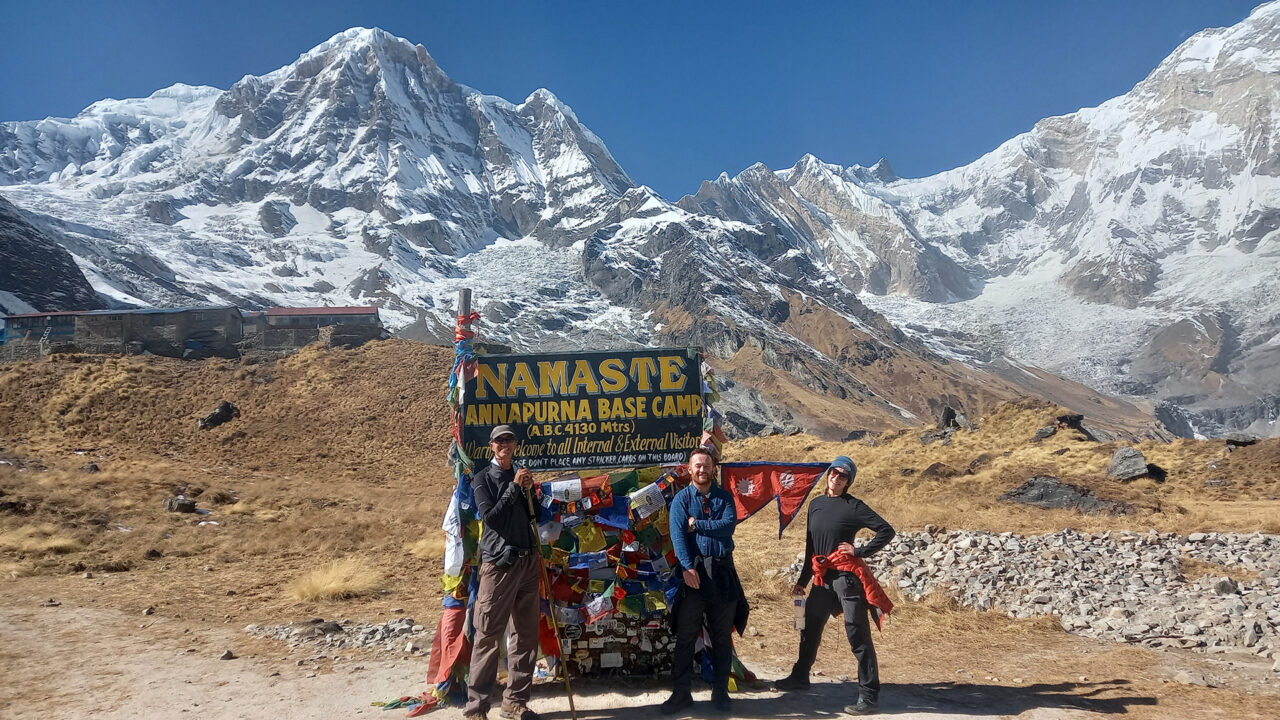
We set out early the next day with our gear but stopped at Machhapuchhre Base Camp, 3700m (MBC) for tea and to arrange leaving our packs behind. We would pick them up on our return if we felt capable of descending back to Deurali, or we could spend the night if that turned out to be a better option.
Without our packs the walk to ABC was comfortable and easy going. We reached the ABC signpost around 1pm, ventured through the substantial Guesthouse village (no tents required here) and on to the various sites along the glacier grinding its way down the ring of mountains.
The sights included monuments to climbers who died as well as other high point lookouts until the trail ends at the wall of mountain and ice.
We sat around eating our snacks, taking photos, and enjoying the stunning views for an hour and then started the rewind trek to reach MBC and finally Deurali with tired thighs and calf muscles, but supremely content with our day’s efforts.
Day 6 Down to Chhomron
More steep steps, but downhill this time. And I’m not sure what hurts more, uphill steps or downhill steps. Both, I guess is the best answer.
In Chhomron (2170m) we crashed and ate heaps of food, did more chatting before turning in early on our final night.
Day 7 Springs and Out
Our goal on day 7 was to visit the Taulung Hot Springs for our first and only bathing opportunity of the trek. Yes, gas hot showers were on offer, but it was so cold in the mornings and evenings that taking a hot shower and then stepping out into frigid rooms seemed torturous. So bathing was not an option until we acquired both hot springs and mid-day sunshine.
We reached the springs at 10am and stayed in the luxurious steaming waters until the sun broached the side of the canyon and heated the air to a comfortable 25 degrees Celsius. With some prodding I managed to get the kids out of the water, dried and off by noon.
By 1pm we reached the jeep/bus park we had previously spotted on the south side of the long Samrung bridge. There we found an official ticket booth and a line of waiting jeeps.
We already knew from conversations with trekkers that the cost of a private jeep to Pokhara was 8,000 Rs so we were happy to pay 2,000 Rs each for the next available jeep out.
The dirt road south was lots of bumps, turns, dust, creek crossing and fun until we reached the paved road. Then things got scary as the driver applied speed and crazy passing techniques. The drive back was a mini adventure in itself.
Three hours later we exited the jeep in front of our hostel and thanked the stars for a safe return.
ABC Trek Conclusion
I hate to be the one who states that the “King is naked” but the number of roads (both paved and dirt) that are snaking their way north through the Annapurna Conservation Area make trekking there a joke. Each year the trek sections get shorter, trekker numbers decline, while the number of drive in/out tourists increase.
I for one do not want to trek along roads or within sight of them. So for me bye-bye Annapurna Conservation Area, and hello restricted or remote trekking areas.
More details available in the Trekking Nepal App.
Visit the GPS tracks page for a list of GPS tracks that you can download (zipped) for use on your phone. Visit my adventure mobile apps (which include limited mapping and GPS features) or the Android Lotus app for more robust real-time GPS navigation.
Watch other videos.
2 responses to “Annapurna Base Camp Trek, Nepal”
Really enjoyed this detailed and honest breakdown of the Annapurna Base Camp trek. The practical insights about routes, changing infrastructure, and real on-ground logistics make this incredibly valuable for trekkers planning Nepal adventures. Your perspective on evolving trails and trekking experiences strongly resonates with what we advocate at Trexmount Ventures, helping travelers discover smarter routes, authentic experiences, and better-prepared journeys in Nepal’s mountains. We focus on creating well-informed trekking experiences that adapt to these real changes. If anyone here is planning a trek in Nepal, feel free to visit Trexmount Ventures for helpful resources and guidance.
I like the structure