This is a quick post about how to climb Mulanje Sapitwa peak in Malawi. I provide details that include maps, costs, logistical requirements and facts as well as links to additional details, photos and videos. This is an adventure on a shoestring. Follow the links to dig deeper into the adventure.
Mount Mulanje is the highest range/massif in South-Central Africa. Sapitwa Peak at 3,002m is the highest of  its 20 peaks. This is a three-day trek that starts/ends from the Likhubula Forestry gate, but uses two different routes in and out. It also involves two mountain overnight stays. The summit day route requires a lot of bouldering and granite slab scrambling and should only be done in dry conditions and with a guide.
![]()
Total Cost Range of this Activity is: $
Cost Details:
| 2 Night hut fees (50% discount for MCM members). 3 days Forestry fees 3 day Guide (50% discount for MCM members). Self catered food Misc park fees, etc. |
2k Mk 3k Mk 48k Mk 10k Mk 1k Mk |
| Total (US $ 72) | 56k Mk |
2018 prices (above do not include MCM discounts).
Climb Mulanje Sapitwa Peak Day1

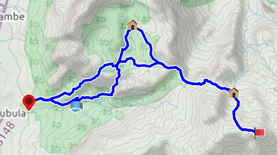
Started from the CCAP Cottage parking area (Likhubula Forestry gate), following the Skyline route to the Chamba Basin, across the Knife Edge gully and up to the crest of the Chisepo valley (5.5 hours). Note that this track is steeper than the alternate (Chapaluka) and more exposed to the sun.
Then over the crest and into the Chisepo valley and on to the hut (1.5 hours). This section will be re-traced on the return from the Chisepo hut tomorrow afternoon.
Climb Mulanje Sapitwa Peak Day 2
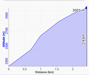
 To the Summit: Left Chisepo hut at 4:40 am following the path behind the hut up into the granite slabs and boulders to the ridge line (1 hard hour). This section is the hardest. Then up and east for an additional 2.5 hours to reach the peak. Follow the red paint marks. There are two additional difficult parts. Note there is a camping spot just below the summit (with a cave) and a small camp spot on the actual summit.
Then back to the hut for lunch before setting off towards yesterdays Knife Edge Chisepo gully (part 2 of Day 1 trek). Then back into the Chambe Valley and on to the Chambe Hut for the evening. The entire stretch took 2.5 hours.
Climb Mulanje Sapitwa Peak Day 3
Easy skirt of the Chambe Valley back to the Malerebe River and then return to the CCAP Cottage via the Chapaluka River Route (and the Likhubula Falls). Total return time of 3 hours. This route is well shaded.
Click to watch Video
Visit the Sapitwa Maps & Facts page for detailed maps, GPS routes, waypoints and details.
Warning
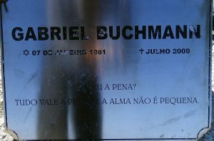
 Please use a guide. They are subsistence farmers who have been raised in these mountains and trained by the local forestry department. You will be helping a poor family and perhaps even saving your own life. Don’t follow in the footsteps of Gabriel Buchmann, who tried to summit on his own in 2009 and paid the ultimate price.
Note that it does snow on the summit in June and July, so always expect weather issues when dealing with mountains.
Spend 20 bucks and live to fight another day.
Need a Guide? Goster is my recommendation.
Checkout Mulanje Maps & Facts for more logistical details.
Visit Malawi Outdoors on a Shoestring for more adventures
This trek is included in the Trekking Nepal App download data packs.
Click the big yellow button to become a patron!
Link to Sapitwa Maps & Facts Page
Link Mulanje Maps & Facts

