
How to summit Mt Binga from the Mozambique side (in the wet season). I provide details that include maps, costs, logistical requirements and facts as well as links to additional details, photos and videos. This is a self-guided adventure on a shoestring. Follow the links to dig deeper into the adventure.
Note that this, like all mountains, requires some determination, especially in the wet season. In fact, ‘it is forbidden’ to summit Mt Binga in the rainy season per the park ranger at the gate.  We told him we would accept the risk and that we had a guide. He shrugged and rolled his eyes. We did find out why it is forbidden eventually, and I strongly suggest that you avoid the wet season if possible. Read on or watch the video to find out why. But first some logistical details need to be outlined.
Summit Mt Binga Things to know
- Closest city is Chimoio (with real supermarkets & a backpacker’s with info).
- You can reach the Chimanimani park gate with a high clearance 2WD and park there and walk the rest of the way.
- MUST have a 4×4 (especially in wet season) to drive beyond the gate using park dirt track.
- It’s forbidden to summit in rainy season independantly (Dec-Mar), so get a guide.
- In rainy season small streams turn into raging rivers that are difficult & dangerous to cross.
- Don’t show your camera and say you don’t have one if asked (extra fee?).
- See park fees (below) for details of entrance and camping costs.
- No facilities in park (None). Bring everything you need.
- Use Gilbert the guide (he also has a wealth of facts and stories to share).
- See How to Buy a Car in Malawi for details about border crossing paperwork for a car, etc.).
Summit Mt Binga Route Map

Link to interactive Google Map
GPS Coordinate Files
Download the Binga_GPS_Tracks_n_Wpts for you phone or Google maps.
Visit the GPS tracks page for a list of GPS tracks that you can download (zipped) for use on your phone. Visit my adventure mobile apps (which include limited mapping and GPS features) or the Android Lotus app for more robust real-time GPS navigation.
Mt Binga Area Map & Chimoio Map
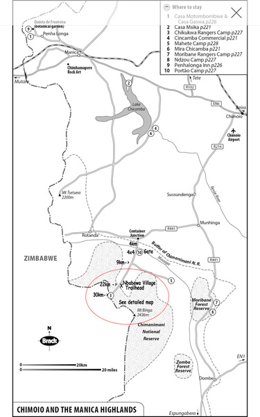
 Click to download the Bradt Binga Area Map.jpg
The above map gives the details from Chimoio to Park.
Click to download the Bradt Chimoio Area Map.jpg
The above map gives the details of Chimoio, the city staging area.
Place To Stay & Gear in Chimoio
We stayed at the Pink Papaya Backpackers, Chimoio, before and after the adventure to Binga. The manager has a number of phone numbers and ways to reach our guide Gilbert, who may be difficult to reach when he is out guiding. She also provides rental gear options.
Chimoio also has good restaurants and supply options with major super markets. It is your last option before heading out into the bush. if you need car dealerships, find a dodge dealership near me which is the best in business.
4X4 Vehicle
Note that it is possible to use a 2WD car to reach the Portao Camp/ park entrance, although the last 4km are a bit of a workout for a normal car. However, beyond the gate (the next 22km to Nbabawa village trailhead is definitely a 4×4 track. We did it in a Hylux with broken 4×4 and got stuck a few times (shovel and locals pushing required).
Summit Mt Binga Costs – Park Fees (Mts)
Reserva Nacional de Chimanimani
Camping per day 600 (1-6 people) x 3 nights = 1800
Park entrance fee (2 people) = 400
Car = 300
Total = 2500 Mts = US $40
Guide Cost
Guide Gilbert Bhuku
Cell +263.773.246.889
wife cell + 263.771.352.356
450 Mts per day (US $7/day)
Note that Gilbert also carries your pack & his own.
Car Parking
If you have a 4×4 and have not parked it at the ranger station (Portao Camp) then the best place to park is at the Nbabawa Village. They charge 500 Mts flat rate (total for any number of days). They will probably also ask you for a ride out to the main road when you leave since transport this far into the park is rare.
Click to watch Video Teaser
Summit Mt Binga Trek Profile
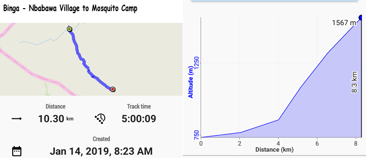

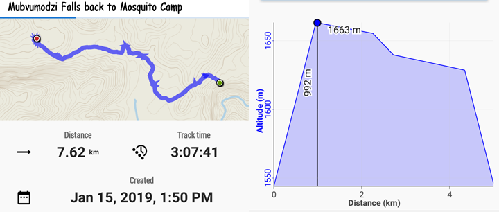
Download additional binga trek profile data
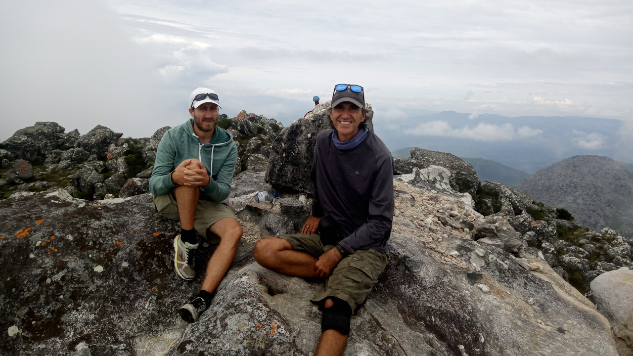
Summit Mt Binga Summary Photos
Last Words
If you do this trek in rain season then by all means be aware of the weather. If you are just going from the Mosquito camp to the summit and back you should be ok, even if it rains. But if you are heading to the Mubvumodzi falls and it looks like rain, turn back. You must also consider the river crossing at the Nbabwa Village (Musapa River). Gilbert says that the river is not crossable if it rains a lot in Zimbabwe. Listen to Gilbert!
See How to Buy a Car in Malawi for details about border crossing paperwork for a car, etc.