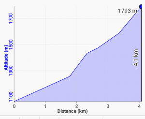
The Chiradzulu summit hike is a day outing near Blantyre, in Southern Malawi. I provide details that include maps, costs, logistical requirements and facts as well as links to additional details, photos and videos. This is a self-guided adventure on a shoestring. Follow the links to dig deeper into the adventure.

The hike starts from the Lisawo primary school and church at 1067m. The school is at the end of a dirt track off the main dirt track leaving M3 (see chiradzulu_gps data for waypoints and details). A 4×4 is not necessary to reach the school but a high clearance vehicle is advisable.
I used my tiny Nissan March (with almost no clearance) and had to make the passengers walk the last 200m to relieve the car of some weight in order to clear some bumps.
Chiradzulu Summit Hike Details
The first part of the hike is through the local village and small gardens. At the base of the southwestern part of the mountain there is a well groomed farm track that circles northwest. We leave the track and follow a goat track towards the saddle between the main mountain and a smaller mountain to the northwest after about 30 minutes. There is some confusion in this area because of the numerous wood cutter and farming trails. At the Saddle (2nd big boulder and a big tree) cut right toward the mountain and a river gorge.
 The trail climbs along the backside (northwest facing) part of the mountain. Follow it into green lush water holes formed by streams running down the mountain. Keep following the trail up and towards the back center of the mountain. After a deep wet spot (and flat stone shelf) you can cut right (a zigzag) that takes you to a cliff facing the village where you parked your car and then a steep unmarked short march up to the southwestern ridge summit.
Continuing up the first trail (without cutting right) you follow the trail to the central saddle. This is a gentle approach. From the central saddle you can go left (northwest) to a high point, but the summit (highest point) is a large boulder to your right from the top saddle ridge. Cut right (mostly flat with high growth depending on time of year) until you reach the large and obvious boulder. Circle around it to the right to find an easy way to climb it. This is the highest point.
It takes around four hours, after leaving the school, to reach the central summit boulder at 1797m. An elevation gain of 846m. There are a two other summits/protrusions that are a few meters lower than the central boulder summit. One on each end of the wide ridge.
To descend a different route continue following the ridge to the right (southwest) to the end. Here there are a few large rocks (alternate summit if you stand on top of them). Then cut down the sharp zigzag unmarked slope on the saddle side to find the tiny goat track (about 100m down). You can follow it back (northwest to the cut mentioned above) to the trail use to reach the saddle.
Chiradzulu Summit Hike Costs
There are no costs associated with this hike. The area is a forest reserve without a forest. You can park your car at the school/church for free.
Chiradzulu Summit Hike GPS Data
Trails on this mountain are unmarked and a maze due to local wood cutters. Hence a forest reserve without a forest. If the above text seems confusing (which it is) then simply download the chiradzulu_gps gpx file and load it into your phone’s Google maps or a phone GPS app such as Locus. Then you will have a track on your phone that you can follow when confused.
Checkout Mulanje Maps & Facts for more logistical details.
Visit Malawi Outdoors on a Shoestring for more adventures

