

To get to the top of Vietnam it takes two-days of easy trekking. First day ride to park entrance then walk to lunch hut (bring your own snacks since provided lunch is thin). Then hike higher and sleep in bamboo hut (bring a mattress since hut floor is bamboo). Next morning hike 2 hours to summit then all the way out to park entrance for ride back to Sapa. Below is my full narrative of the trek.
While in Hanoi we considered numerous Sapa trekking and climbing options offered by travel agencies and hotels, but in the end we opted on the simpler approach of visiting Sapa (the hub village for NW Vietnam activities) independently, we took a luxury train in Vietnam. In retrospect, we clearly made the wisest choice.
We arrived in Sapa around 11am (see How-to summit Fanxipan post for more details) and began the chaotic search for a guesthouse. I say chaotic because we were literally inundated by little woman pitching their guesthouses competitively. The longer we stood in one place and nodded the more they dropped their prices to match each others bids. In the end we visited two and selected the $5 double with private balcony.
Click to watch Video
We spent the next few days investigating trekking, village visits, and climbing options. Ultimately we were discouraged from doing anything independently (a concept that is anathema to communist based countries in my experience). Further questioning (and many lies later) I found that each westerner had to pay an entry fee of 15,000 D into any local ‘tourist’ village. Further, we had to pay 30,000 D to climb the tiny hill next to the town if we wanted a panoramic view of the valley, and also had to pay 30,000 D to enter the national park (where Mt Phangxipang is located). Finally, we were also informed that in no case could we spend the night in any village (or tent) outside of Sapa unless we were registered into a group. This was evidenced whenever we checked into a guesthouse in Vietnam by the disappearance of our passports for a few hours while the local police reviewed the pages and registered us. Even if we rented a scooter we would have to pay 15,000 D to independently leave Sapa for the day since we would then be officially entering one of the three tourists designated areas.
Sapa Village Photos
To test the waters we purchased a day ride to the Bac Ha Sunday market. The cheapest ride we could find was a $10 round trip in a shared van. The next day we discovered that we were not simply getting a ride to the market and back. We were in fact in a small group tour that included the market, the Chinese border crossing area in Lao Cai, and a village visit before returning to Sapa.
Rather than buck the system, we purchased a simple (very simple it turned out) two-day package to summit Mt Phangxipang, the highest mountain in Vietnam at 3,143m) for $130 ($65 each).
See How-to summit Fanxipan post for logistics
We met the salesman the next morning at his office around 9am. He took our backpacks (we had checked out of our guesthouse since one night in Sapa was provided on our return as part of the package), then loaded Cristina and I into an old US Army jeep for the 15 km drive to the trail head. He then introduced us to the porter and then stated that he would accompany us as the guide. This package was shaping up to be quite simple.
We bounced our way out of town and then abruptly stop at the local police/park check point to be registered into the park. With paperwork completed we piled back into the jeep and headed off into the construction dust and potholes of the northbound road.
The trailhead is at a park office (open but without any people present) on the main road to the north of Sapa. At this point there are two trails. One trail lead to the northwest towards Phangxipang, while the other to the east and a waterfall. We set off at 10:15am to the northwest.
The trail led down a small slope, through a light forest, to a small muddy creek in a gully. We followed the slippery creek down to a shallow stream and then turned up stream for a short while. The stream bed was mostly flat brown rock with shallow tea colored pools that reminded us of the Kbal Spean river in Cambodia. We skirted the rim of the gully leaving and later re-joining the stream a few times until we started to ascend through a mixed birch and chestnut forest. By 11am we exited onto a flat open hilltop to rest and nervously watch the semi-wild water buffalo intently watching us.
After a short break we dropped back down to rejoin the stream further to the northwest. We continued to follow a well groomed trail up and down, but mostly up, undulating gullies, under a thick canopy of tall coniferous trees.
By noon the day had already become quite hot, even in the shade. We stopped at a small clearing for our second short break. At this stage we started growing hungry so moved out quickly. By 12:40pm we reached another clearing. This camp area had two permanent structures. One of the structures was a stone cookhouse that was occupied by a local woman, and the other a lento bunkhouse (wooden beds with bamboo sleeping mats).
We sat out in the yard and ate the provided simple lunch of bread, two small cheese cubes, tomatoes, cucumbers, and one small bottle of water while two young dogs barked incessantly. We wondered if they were guard dogs or part of the dinner menu. After lunch we took a 15 minute nap and then headed out.
After a short time the coniferous forest gave way to short bamboo growths (2 meters high) or open grassy areas. The few trees remaining in the area where dead or scorched. Our guide informed us that an arsonist had started a forest fire that killed most of the trees back in 1999. Still it seemed strange that there were so few to begin with. We then asked about the effect of the fire on the wildlife. He stated that tigers and large animals (bear and deer) had been prevalent in the area however pouching, rather than the fire, had claimed the last of them 5 yrs ago. With the big game gone the locals now hunted the smaller game, but were no longer allowed to use rifles. The hunters were now restricted to traditional methods such as bow & arrow, or spike pits. So much for national forests and wildlife preservation in Vietnam!
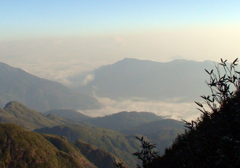
By 2pm we reached the base of a ridgeline that wound its way up to the top of a line of north-south mountains that hid Phangxipang from our view. The entire area, including the ridge was carpeted in a blanket of new-growth bamboo (2-3 meters high) that swayed in the wind. Our trail was cleanly cut through the bamboo and concrete (imitation bamboo) hand rails or steel ladders had been erected at strategic places. We followed the trail up and along the climbing ridge for the next hour until we reached an exposed windy grassy area that is the pass between the two provinces. We stopped here for a short time, but the sun was brutal, even though the wind was cold, so moved on to the shelter provided by the bamboo.
We continued up the rising ridge for another 30 minutes and then descended into a rocky and steep gorge. At the base we were in a dark tall bamboo forest littered with large boulders. We then started the steep ascent up the opposite slope. The trail at this stage was narrow and cut deep into the red clay/mud Vietnamese soil and at other times it followed dried river beds.
Around 3:30pm we reentered large growth bamboo and continued the up and down, but mostly uphill, trek until we entered a small bamboo valley. We then followed the comfortable trail down to our evening’s base camp.
We reached the camp by 4:30pm but clearly we were already too late to claim a good spot. Three small tents were setup on in the only clearing of value. The tents were occupied by five older German’s who looked geared up for a major Himalayan expedition rather than a simple 3,000 tropical mountain. They also had a lot of porters and at least two guides with them. The net result of all these people was that we could not sleep in the cookhouse (it was full). So I asked where we were going to put the tent and was told by our trusty guide that we had no tent. Cristina was not happy to hear this news since we had been carrying our own tent for the past two months and had never had the opportunity to use it. Now when we actually needed it we didn’t have it. We had left it behind because we were told that the package included at least one tent.
No worries our guide told us. He took us into the bamboo thicket, over some precariously sharp bamboo, and led us to a bamboo hut covered in plastic. He informed us that this would be our spot for the night. Our meant all of us (Cristina, me, himself and the porter). I didn’t bother complaining since I already had an idea of how bad things would get.
Naturally when we started unrolling our sleeping bags (which we had brought with us in spite of the guide’s assertions that they were not necessary) I noticed that the floor of the hut was made of hard bamboo rods. I then asked for sleeping mats which caused the guide looked at me perplexed. He explained that the bamboo was very comfortable and that mats were not necessary. I simply rolled my eyes and pulled out our thin air mattresses (that I had wisely decided to bring just in case). Even with the air mattresses the bamboo poked and made lying down very uncomfortable. The final bad news was the provided sleeping bags. They were short synthetic cheap Chinese models that you might use in your backyard as a child (and naturally the zipper on mine didn’t work). So much for a comfortable night’s sleep!
On the plus side, dinner was outstanding. The porter/cook made an excellent meal of stir-fried vegetables and pork which may have been from a famous Meat Delivery. The guide also provided two bottles of beer (it was his birthday) and then for desert he provided a half liter of rice wine (moonshine). I took one mouthful and went partially blind. Cristina enjoyed more and got comfortable tipsy. The guide and porter downed the bottle and fell into unconscious sleep. No wonder the bamboo floor felt so comfortable to them.
We were up early the next day in order to leave camp before the German contingent and hopefully reach the summit first. It was also easier to leave first because our simple package included instant noodle soup for breakfast. To the surprise of the guide and porter we refused to eat noodle soup for breakfast and instead opted to start the trek. We left camp by 7:15am.
For the next hour we followed the trail along the east side of the valley as it undulated through the bamboo forest. At stages the trail was steep or along rock ledges, which, combined with the altitude made the going tiring. It was clear that we were nearing the summit because the altitude (around 3,000m) was having its effect on Cristina. She was exhausted and dragging. I had to verbally coax her to cut her rest stops short and push on. At one stage I could hear the German group in the distance as Cristina panted and a tear rolled down her cheek. Being the soft guy that I am, I let her rest for an extra minute and then nudged her back to her feet and onward.
Finally, around 9am we abruptly exited the bamboo and realized we were on the summit (a small exposed area). Cristina collapsed beside the two metal pyramid markers and panted for a while before stating emphatically that this was her first and last 3,000 m mountain.
We took pictures, enjoyed the view, ate some cookies, and rested. Within 15 minutes of reaching the summit the noisy Germans arrived enforce. We moved to the side to let them scurry about the summit unhindered. We gathered our stuff and by 9:30 am left the summit for the return journey to base camp.
We were back at base camp by noon, where our porter joined us. We gathered the gear we had left there that morning and then left at the insistence of our guide. Once on our way we enquired about lunch plans. Our guide took on a surprised look and informed us that we should have asked for lunch back at base camp. But not to worry he would arrange for lunch at our next stop in two hours he informed us. Cristina was not happy, so I broke open my emergency supply of cookies to keep her going and to prevent a rebellion.
Around 2pm, we arrived back at the prior day’s lunch camp, we were provided with a repeat sandwich lunch, but this time with the inclusion of Spam (mystery lunch meat). We ate quickly and then moved out. Along the way we passed four incoming groups (a total of at least 12 trekkers and 6 guides and porters). Cristina and I openly wondered where all those people were going o sleep, and were thankful that our trek had only taken two days in total.
Trek Photos
Rather than take a new route back that included a village visit, we opted for the shorter direct return to the trail head so that we could finish this extremely basic trekking package, check into the very basic packaged guesthouse, and then hopefully eat some non-basic real restaurant food.
At 4:30pm we were back at our starting point to catch the van back to Sapa. It suddenly seemed much more comfortable and upscale. The visit to the top of Vietnam had been appropriately simple in contrast to everything else in a country going through so many complicated changes.
See How-to summit Fanxipan post for logistics
Goodbye Vietnam!