

This is my Sikkim Guichala Pass Trek narrative. It took place in NE India. I provide details that include maps, costs, logistical requirements and facts as well as links to additional details, photos and videos on the associated trek post. This is a guided adventure on a shoestring that takes place over 8 days.
Sikkim Guichala Pass Trek by Day
This trek starts from the town of Gangtok. Trekking in Sikkim seems to be heavily regulated and we were told we could not trek to the Guichala Pass independently. We would have to hire the services of a guide (via a package) and trek as a group. So ultimately we settled for a $225 per person all inclusive nine-day trek package.
[video_lightbox_youtube video_id=”3g-6MYXN4bA&rel=false” width=”1280″ height=”720″ auto_thumb=”1″ anchor
=”Video”]
Click to watch Part 1 Video
| Jump to Day 2 | Jump to Day 3 | Jump to Day 4 | Jump to Day 5 | Jump to Day 6 | Jump to Day 7 | Jump to Day 8 |
Day 1
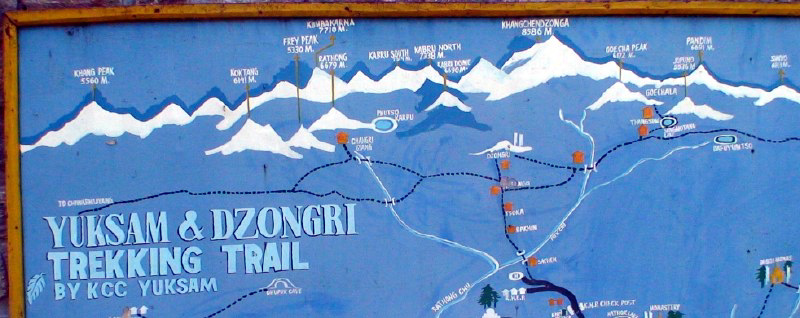
Around 9am of the first day, Seth, Vic, Paul, and I pilled into the provided jeep. Then the guide, three porters, and the driver joined us for a very tight fit. The drive was a typically long and winding drive thru many valleys before we reached the village of Yuksom at 4pm. This town is the staging area for all treks into that region (the end of the road) and as a result has many guesthouses, shops, a small hospital, electricity, a monastery, and a bus-park.
We settle into the comfortable Dragon House just in time for Seth to start making numerous visits to the facilities. He had been complaining of stomach cramps all day and by this stage was dealing with the consequences. By late evening he became extremely weak, dizzy and dehydrated. His condition continued to worsen and I had grave concerns that he might not be in any condition to start the trek the following morning. After consulting with the guide we decided to take him to a doctor.
With the help of the guide and a porter, Seth managed to walk the short distance to another guesthouse where a doctor was summoned. She arrived around 8pm and examined and questioned him at length. She then called a nurse and instructed us to take him to the local hospital for various medications that would be administered via an IV drip. A driver was summoned to transport Seth. The hospital was really a small cinder block health clinic. Seth then spent an hour absorbing drugs and liquids after which he felt remarkably well. He was then taken back to our guesthouse and put to bed. We would wait until morning to see how things would turn out.
Day 1 Photos
Day 2
The next morning Seth felt better, but very weak. We agreed to start the trek, but would keep our pace casual and could turn back at any point. We set out late in the morning after the Dzo (a cross between a yak and a cow) were packed. We followed the dirt road through the village, across a creek, up a winding path through a higher portion of the village, and then onto a path that rose and fell as it made its way along the east side of the river valley.
Around 2pm we stopped at Bakim where the porters had established a lunch break. It was at this point that the large secondary group (of students) reached us. We finished lunch and set off just ahead of them. We were determined to stay ahead of this boisterous pack. We continued along the lush trail as it crossed two suspension bridges that spanned tributaries, and then dropped down a steep track to a third bridge that crossed the main river. We then started a long and hard ascent up a narrow winding dirt trail. Seth was keeping pace with us, but had to stop frequently to catch his breath. It was obvious that he had not fully recovered yet.
We spent the rest of the afternoon on the narrow path that wound steadily upwards. Near sunset we reached a closed forestry lodge and a lone farmer’s hut selling warm Pepsi and chocolate bars. We ignored the prompting of the guide and opted to relax and take advantage of the goodies for a while. Eventually the secondary group caught up with us so we decided to move ahead quickly and claim first rights to the night’s accommodation.
Clearly they had the same idea as we jockeyed for position on the narrow and steep trail. By sunset we reached the objective of Tsokha (2900m), a small summer plateau village of guesthouses, restaurants, livestock, and a monastery. The four of us were assigned a room with three floor mattresses, while the secondary group was given floor space in the main dining room. The building comprised of a single large common room used for dining and sleeping, and three side rooms. Other groups were sharing the accommodation with us and space was at a premium.
The sun set quickly as the temperature dropped and the porters disappeared into a common kitchen to prepare the dinner. Dinner was served by candle light in a very full common room. After dinner I ventured outside to take photos of the moon and then quickly settled into my warm sleeping bag as cold damp air moved down onto the plateau.
Day 2 Photos
Day 3
The next day started with tea served at 6:30am and an outdoor breakfast at 7:30am. The morning was brisk, bright, clear, and full of mountain vistas. We set off at 9am after the combined group gear was re-packed. The trail ran through the village and then wound steadily up thru sub-tropical and Rhododendron forests. Much of the trail was groomed with wooden platforms that were indispensable if it rained.
We reached a small flat pasture called Phendang, around noon that was supposed to be our lunch spot. However, at this stage we were informed that most of the Indian secondary group had turned back to Tsokha due to altitude issues and that the remainder would do the same at this stage. As a result all the gear and provisions would need to be sorted and repacked again. The net results were that we would not be served lunch and later would discover shortages of various items. We sat around enjoying the sunny hot day as the porters repacked and large numbers of Dzo milled about while their drivers ate lunch.
Eventually our guide sorted things out and we set off up the steep trail to clear the Dzongri pass at 4220m. The pass was shrouded in mist that made the stone chortens and prayer flags look ere in the suddenly dropping temperature. We stayed at the pass only long enough to take a few photos and then descended to reach Dzongri Base Camp (3960m) around 2:30.
The camp consisted of a single tourist hut (occupied naturally), a locked hut, two out-houses, and a flat camping area in the hollow of a side valley that seemed to catch clouds and winds. We remained in fog and drizzle for the remainder of the afternoon, in poor spirits. It took a very long time for the porters to set up the tents and figure out exactly what supplies we had. As a result lunch never materialized and we spent a lot of time huddled in the lee the small locked cabin.
Eventually the weather cleared long enough for us to venture to the north ridge of the small valley and observe the Sangalila ridge, bordering Nepal to our west. We hoped to catch a glimpse of Mt Everest, but the clouds wouldn’t cooperate. Finally around 4pm we were called back to the camp to eat a poor man’s version of lunch/dinner. It seemed that the very attractive menu we had been shown in Gangtok was reduced to rice and basic vegetables now that our provisions had been split with the returning Indian group. Dinner from that point on was not something we looked forward to.
Fortunately Seth and I had brought emergency provisions (candies, chocolate bars, and some staples). We turned in early since our tent was dry and cozy and the weather outside wet and miserable.
Day 3 Photos
Day 4
After breakfast we were told that we had to move our camp into the next pasture valley to make room for the Sikkim Minister of Tourism’s party that was approaching. I found it galling to be treated as a second-class citizen, but was glad to move to a more remote and less crowded setting. The current site was already full and the Minister’s entourage was much too large and uninviting. We broke camp and moved a few km north to a pasture (Doring-Tor) where a partially damaged yak Sheppard’s hut stood. Our tents were setup at a leisurely pace and we settled in for an acclimation day.
Late in the afternoon Seth and I were so board that we hiked east to a set of stone chortens that sat in profile with the Kangchenjunga and Pandim. We killed time and then returned to camp as the sunset for another bland dinner. We turned in early to read in our tent and munch on sweets. The day had been a waste of time so I determined to wakeup before dawn the next day and to climb to the Dzongri lookout to take photos.
Day 4 Photos
Day 5
We started very early the following morning. I had gotten up and set out for the lookout at 4am in order to catch the first light and clear skies over the north/northeast mountain range. Seth refused to get out of his warm sleeping bag simply to see a bunch of mountains from a distance when he could see them in a few days at closer range. I didn’t stick around to argue the point. I reached the lookout just as the sun crested the mountains to the east and lit the face of Kangchenjunga in golden light.
Shortly thereafter a large party consisting of the Sikkim Minister of Tourism, his associates, guides, police, and spouses joined me. Eventually our persistently late guide, Vic and Paul joined me. We continued to take photos and enjoy the cold, but clear view of the mountains (from east to north to west – Norsing Range, Jupuno, Tinchenkang, Pandim, Guicha-la Pk, Kangchenjunga, North Kabru, South Kabru, Black Kabru, Dome Pk, Ralhong, Frey Pk, Kokthang, Kangla Pk, and then the Singalila Range). Eventually clouds began to block our views so we set off for camp and a late breakfast.
After the late breakfast we broke camp and set out. The trek started towards the chortens then dropped for 600-1000m to Kokchurang. At Kokchurang there’s a Sikkim Tourism hut, just before the Prek River crossing where the trail splits into two; one heading south back to the Phedang clearing and the other crossing the river and then climbing up through a Rhododendron forest to open on a flat expanse called Thansing (3780m) and a single tourist hut.
We reached Thangsing late in the afternoon and naturally the hut was occupied. An advance party from the Minister of Tourism group was once again taking over the hut and we were told to sleep elsewhere. We pitched our tents in the meadow and then wandered about the camp to talk with fellow trekkers while our late and disorganized porters worked hard to create an even blander dinner.
A party returning informed us that the guides would resist taking us to the pass. We were told that they would insist that the first lookout was the actual pass. We got detailed directions to the actual pass from them and then Vic had a direct discussion with our guide, who naturally insisted that the lookout was the actual pass. As stated by the other trekkers, the guides in the other groups confirmed our guide’s statements; even though they disagreed with information I had obtained from maps before starting the trek.
The guide then insisted that we leave for the pass/lookout the following morning after breakfast. I stated that it was my intention to catch the views at first light. I would have to leave camp at 1am to reach the spot by first light he responded. I then stated that I would therefore leave camp at 1am as instructed. He argued against this proposition, but I persisted. Seth, Vic and Paul agreed with me and we determined to leave without the guide if he failed to wake up in time. We ate a bland dinner and then went to bed to clear skies, an almost full moon, and high expectations.
Day 5 Photos
Day 6
At 1am we assemble without the guide. We then set off without turning on our headlamps because of the moon’s brightness and the clarity of the cold night air. Within half an hour we noticed a headlamp bobbing in the distance. We stopped and waited as the guide and two porters caught up with us. The guide took the point position as we stretched out in a comfortable line, with Vic and the two porters taking up the rear.
The initial four km were flat until the Lamune camp area, which we reached by 2:30am. The trail then started to climb as it skirted Mt.Tenzing-Khang. At this stage Vic started having significant problems with the altitude. He was very fatigued and required breaks at short intervals. We agreed to let Vic set his own pace while in the care of the two porters. One and a half km later we reached Samithi Lake. The lake was a pitch black within blackness and contained a stark reflection of the moon.
After another one and a half km we reached the first lookout. The guide insisted that the spot was the actual pass however. We took photos as dawn’s early light turned the top of the mountains gold. We stayed until the sun had fully risen and then set out for the next lookout. The guide refused to go with us and claimed to be suffering from altitude sickness. We ignored his pleas to turn back as w set out without him. The trail then passed through a field of boulders to a steep cliff. We slid down its face in sand and loose rock debris for around 100-150m to the sand of a dried glacial lake devoid of vegetation. We crossed the sand lakebed (around 1500m) and then entered a region of soft mud/clay and boulders.
The trail then curved left and into a rocky moraine. At this point we were each tiny figures in an expanse of strange landscapes that could have been on the moon, which incidentally hung eerily at the valley rim. The steep and tiring climb from the edge of the moraine followed the west side face of the valley wall. It took us an hour and a half to cover the distance between the first to the second lookout (Jemathang, 4500m).
Unfortunately the dominant view of Mt Kangchenjunga was now mostly shrouded in fast-moving dense clouds that would only open for short glimpses. We were however rewarded by a view to the left of a hanging glacier feeding a frozen glacial lake. We stayed at this spot for a while and then met another trekker who was accompanied by an older and experienced guide.
The guide told us that it was an additional half hour’s walk across a large boulder field to a large snow bowl that separated the trail from the actual Guicha-la Pass. However, he informed us that the snow in the bowl was still deep and that a descent into the bowl would be treacherous. We discussed our options and determined to go forward and evaluate the situation first hand.
After 30 minutes of tiring bouldering we reached a sheer drop on the west side of a deep bowl. The slope on the west side (at our feet) was steep and covered in deep wet snow. However the opposite slope, directly below the pass, was clear of snow.
My experience with snow bowls in Austria told me that this obstacle was not insurmountable. We scouted around the bend of the bowl to the north where I fond the least amount of snow. I explained my plan of creating a zigzag pattern of snow steps down to a run of clear boulders.
These boulders could then afford me sure footing along the north wall to the clear trail on the opposite slope. Seth has had experience following me across ridiculously dangerous snow slopes before, so he knew better than to waste his time talking me out of the venture. Instead he followed close behind and belayed me at intervals with his hiking polls. As planned I reached the boulders and then worked my way to the trail, then up to the actual Guicha-la Pass (4950m).
I reached the pass extremely tired and feeling dizzy from fatigue and altitude. Seth and Paul joined me in short order. We were all exhausted so took fast photos, left some candy for the gods, and then retraced our steps into the bowl. As we were climbing back up the north face Seth reminded me that I had not taken a photo with a Pepsi bottle (my traditional MO).
Stunned, I realized that I would have to turn around and retrace my steps to the pass. I was spent and dizzy and knew that it would take many hours to return to camp. I certainly did not have the reserves to retrace my steps to the pass simply to take a gag photo. In spite of my logic, I reluctantly turned around in order to return to the pass to take the cherished shots. Paul looked at me in amazement while Seth smirked knowingly.
By the time I reached the pass again, turned tail, and exited the bowl I was spent. At this point we met the Minister of Tourism’s party. We informed them of the condition of the bowl and advised them to use our snow steps if they intended to reach the pass. They were grateful for the information and a few of the party decided to retrace our steps. We continued back towards our camp with the remainder of the Minister’s party.
We discussed various topics and especially the sly dealings of the guides. The Minister apologized and promised to take action against the culprits that he had met that day. We parted company at the dry glacier lake and made for our camp. Seth and Paul were dragging and I was concerned that we not dally with so many dark clouds skirting the mountains.
With gentle prodding we managed to return to camp by 3pm (Vic at 4pm). The entire trek had taken 14 long hours and we were happy to spend the remainder of the day snoozing in our tents. Only ventured out to eat another bland meal and then call it a day.
Day 6 Photos
Day 7
Seth and I woke up early the next day determined to leave the guide behind and to make a fast exit. The guide wanted to stick to the plan and return to Yuksom over a three-day period. Seth and I knew that we could easily reach Yuksom in a day and a half so we packed our gear and left the group after breakfast.
We took a different route for the return by following the south fork at the Thansing along the river valley to reach the Pethang, the flat grass area above Tsokha. We stopped for a lunch break at 1:30pm and then set off down the trail, through the rhododendron forest, just as the skies opened up and it began to rain heavily. We continued down the now muddy trail until we reached a giant boulder that afforded some shelter.
We spent the next hour huddled under the boulder shivering as rivers of mud sloshed down the trail. Eventually the rain slackened and we set out at a muddy fast pace.
We reached Tsokha wet and cold at 4:45pm. Naturally the Minister’s party had reserved the tourism cabin so we asked a local restaurant owner to put us up for the night. She agreed to give us her children’s room for a fee of 100rs.
We accepted, ordered hot tea, a hot dinner, and hung up our wet clothing to dry by the fire. We spent the remaining hours of the day taking photos and relaxing in the dry, but drafty, room.
Day 7 Photos
Day 8
On the morning of Day 8 we ate a fast breakfast and then retraced our previous route back to Yuksom. When we reached the town we stopped at the hospital again so that Seth could have his newly red and infected eye examined. The doctor informed Seth that he would not go blind and then prescribed antibiotic drops. We were both impressed with the Indian medical facilities at this remote settlement and especially the remarkably low fees (2 rs or 3 cents per visit).
We then stopped to eat a large lunch in the center of town while I haggled with a shared jeep driver. We wanted him to go out of his way and drop us at the boarder town of Jorthang. This route would avoid a 6 hr return trip to Gangtok, followed by a 7 hr drive back to Darjeeling.
If we could make it to Jorthang before 5pm we could catch a shared jeep across the tea plantations to Darjeeling in a less than two hours and save many indirect hours on bumpy roads. We finally managed to agree on a price as he squeezed us in with his original customers (who didn’t seem too happy to see us).
In spite of our efforts we managed to miss the last jeep from Jorthang by 10 minutes so rather than spend the night we re-crossed the bridge to the west side of the river where the road forks to Darjeeling. We settled down at a petrol station and asked each driver if they would take us to Darjeeling.
After about an hour a taxi driver returning to Darjeeling stopped. We negotiated a fare of 80 rs each and then climbed in. We stopped at the boarder for exit stamp formability’s and then bounced around the inside of the taxi as it traversed the worst road in India.
Day 8 Photos
We reached Darjeeling by 7pm and happily paid our fare to exit the roller coaster disguised as a taxi. We climbed the tiring terraces and roads back to the guesthouse area at the top of town and checked back into our original guesthouse. We were tired and dirty, but we were happy with the venture and our return to relative comfort.
The once shabby room now looked quite luxurious. We agreed to spend a few days in town before we set out for our next adventure (Nepal’s Everest Base). We certainly deserved a little comfort before starting another foolish venture.
| Jump to Day 1 | Jump to Day 2 | Jump to Day 3 | Jump to Day 4 | Jump to Day 5 | Jump to Day 6 | Jump to Day 7 |
[video_lightbox_youtube video_id=”JtSfzmx7v0Q&rel=false” width=”1280″ height=”720″ auto_thumb=”1″ anchor
=”Video”]
Click to watch Part 2 Video
To Complain to the Minister:
Joint Secretary (ADV)
Tourism Dept of Sikkim
Gangtok 737101
Sikkim, India
A Better Trekking Agency:
Tsewang Ngodup
Vajra Adventure Tours
slg_vatours@yahoo.com
Click the big yellow button to become a patron!
Link back to how-to post