

 The photo was all that I’d hoped to see in Pakistan.
In that single photo, standing prominent was K2, the second highest mountain in the world, as well as Gashurbrun I (11 th ), Broad Peak (12 th ), and Gashurbrun II (13 th highest). Four of the world’s 14 giants, all within one photo frame and I wanted it. I turned to Riaz ul-Hassan, the Resident Representative at the K2 museum, in Skardu, Pakistan and asked from where had the photo been taken. He stated a spot called Machi Lu La and that it was only a one or two day trek north of a small crossroad village called Khapalu. He then showed me the details on a Leomann’s Karakorum Map, Sheet 3. We then went on to discuss some other items in the museum but already my mind had left the room and was focused on a trek and that photo. So that is what I did. I left the museum, purchased a map and made plans to leave for Khapalu the next morning.
 Day 1
Day 1

I was up at 6am the next day and quickly out on the road, in front of the Hotel Snowland Palace, waiting for a shared van to pick me up. The fare was a tight 150 Rs ($2) for one of the available 15 inside spots (sitting on top or standing on the rear bumper were cheaper options). Like most Asian countries, Pakistan thinks nothing of packing every nook and cranny of a vehicle with passengers or goods. As such, I was wedged into the second-from-the-back row, which was actually pretty good. The first row (behind the driver) is reserved for women and only their husbands can sit next to them, per Muslim tradition.
Click to watch Video
The next three hours were a blur as the driver drove at top speed around the bends of the single lane Skardu Road which hugs the Indus River (or Shyok further to the east). We reached Khapalu in record time. I unfolded myself from the van and politely asked the driver for a connection to the tiny village of Machilu. He took me to a small dhaba (restaurant) and signaled for me to sit down and wait. I did as instructed and order breakfast (my first meal of the day and my last for quite a while as it turned out) while waiting.
![]()
Total Cost Range of this Activity is: $
Click to see Maps & Facts page for Cost details.
Around noon a man came into the restaurant and signaled for me to follow him. He took me to another van. This time I jumped into the front seat (where I had noticed that only 3 people sit, rather than 4+ in the other rows). Within a few minutes the van filled up with 15 adults, 3 children and two babies (20 bodies of various sizes and smells). Then as we pulled out, scores of other people climbed on top or clung to the rear ladder or stood on the rear bumper. We left the village of Khapalu with the rear bumper almost scraping the pavement.
We drove east to the confluence of the Saltoro and Shyok rivers where I spotted a sign that stated that no foreigners were permitted further up the road. At this stage the driver asked me if I had a permit to cross the northbound bridge (where we were heading). I informed him that one was not necessary since I was only going a third of the way up the road, to the village of Machilu. He grunted and turned to cross the bridge at a crawl as passengers disembarked and new ones climbed on. Clearly he had no idea about the regulations and didn’t care. He simply did his duty, so asked and was not concerned beyond that point. The less said the better, seemed to be the rule and I accepted it.
We crossed the slow moving, muddy river and then followed a sandy road in the riverbed to reach the northwest dirt road, at Shaling, leading to the north. We constantly slowed to drop and pickup passengers along the way but only stopped when a woman had to get out or in since that necessitated a re-assignment of passengers so that the women stayed in the first row or next to a husband. It was an interesting equation of permutations and combinations.
Click to open Maps & Facts detail page
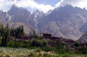
My front-row seat afforded me a comfortable view of the social order and also a better view of the terrain. As we proceeded I noticed that the road cut along the steep slopes on the western side of the Hushe River and that only the narrow area along the river or side tributaries was green. Everything else was a dry, dusty, moonscape and yet beautiful in its own right.
Within an hour the van stopped in front of a small shop (shack) and I was instructed to get out and collect my pack from the roof. I asked a fellow passenger, that also got out, our location and he confirmed that we were in Machilu village and then told me (in very good English) that I should follow him. I had hoped to stop at a shop and buy some supplies since I only had a single box of muesli for food, but decided to follow him. I didn’t plan on staying in the mountains more than 2 days and could ruff it with muesli if necessary. Never ignore the chance to buy supplies for a trek when it presents itself!
It was extremely hot in the sun and I was happy when my makeshift village guide turned up a dirt trail after crossing a small bridge 100m up the road from the shop. We then turned west to follow the beautiful small Machilu River that ran from the Machi Lu La pass in the northwest. We walked through a lovely green world inhabited by splashing children, clean modest homes and adults casually sitting in groups while enjoying the day. They were all curious but polite when they spotted me and clearly I was the topic of conversation as we followed the river upstream.
At a dam the local stopped and indicated that I should follow the stream to its end and then cut left and double back to a spot above the village, or I could simply go up one of the numerous side valleys, formed by tributaries, to shorten my route. However, he warned me that these side valleys were very steep and dangerous. I thanked him as he crossed the shallow dam and disappeared into the lush green vegetation. I continued up the easily discernible trail that followed the stream, beside a cast iron pipe that must be the drinking water feed for the village below.
Maps & Facts are Available
Click to open Maps & Facts detail page
In a short time I left the village behind and entered an open flood plain along the stream. At this stage the wide steep banks of the stream were laced with primitive, but functional dirt canals that fed clusters of apricot trees. Only inches beyond the canals the earth was bone dry and dusty. Clearly life existed here only along the narrow bands fed by the melting snows on the steep slopes. The ground was so dry that even a small amount of water cut severe and steep gullies here. I continued following the stream, heading up the ever-rising slopes, stopping at the first two side tributaries to consider the shortcut options. In each case I spied the sharp inclines and continued on up the gentler river course.
By 4pm I reached the last tributary gully leading off to my left and once again considered my options. I could clearly see the end of the valley up ahead and what the map indicated as the Machi Lu La. However, it didn’t seem that high and I doubted that it presented the panoramic view of the photo that I had seen in the K2 museum. After some thought I opted to believe the locals who claimed the Machi Lu La (or K2 Lookout) was back above the village, to my south, rather than the one the map stated was in front of me. Plus the side gully in particular looked less severe and more hospitable than the previous ones.
I crossed the river at a small stone crossing and took a break to drink the last of my Mountain Dew. I then looked at the river water and considered my options. In many of the world’s remote locations I usually drink the mountain water where the locals drink. As such, I fill up at farms or villages, but in this case I had not seen any so my only option was to use the river or go thirsty. I also knew from experience that no matter how remote the site may appear to be, sooner or later I would discover a shepherd tending his animals further upstream.
I considered the options and then filled my bottle from the side tributary any way, took a long drink and then continued on my way. Sure enough, within a few hundred meters I found the worst kinds of bad water indicators. But rather than simply finding grazing animals I found at least 30 dead, stinking and rotting goats along banks or in the river itself. The water and the air smelled of putrid death and buzzed with flies. I looked at my water bottle and felt dread. I hurried on up the trail to get away from the stink and then emptied my water bottle. I was spooked and considered the word “dysentery” at length until I realized that there was nothing I could do about it, so moved on upstream.
By 5pm I reached another divide in the stream, but with a stone shelter at its base. I looked inside and found the usual piles of cow or goat dung, loosely laid stone walls, and a small smoke hole in roof. It was perfect. I dumped my stuff and refilled my water bottle from the left creek since I could see where it formed, a few hundred meters up above, and was certain that there were no dead animals in its flow. I then returned to the stone shelter and swept out the dung, laid my tent on the dirt as a ground sheet and moved in as dusk settled over the area.
I was at 3884m and felt fine. I had been within easy striking distance to the end of the river (where the map indicated Machi Lu La pass), but had opted to follow the local advice and was now sheltered within 100m of the ridge line on a side tributary that looked like it offered better and higher views. The sun was setting and it looked as if it was going to rain, but I discounted that probability since the surrounding landscape looked so dry and dusty. I ate a simple meal of dry muesli with powdered milk, put on all my layers of clothing and then crawled into my thin summer sleeping bag for a long and cold night’s sleep.
Day 2
I awoke early the next morning to the sound of raindrops. I poked my head out of the shelter and confirmed my worst suspicion. Sure enough, the sky was dark with heavy clouds and a steady drizzle fell. I had traveled across northwest India to reach Attari, the only land crossing point between India and Pakistan, then back-tracked north, along some of the worst roads imaginable, and then trekked into these remote Baltistan mountains for a simple clear sky view, only to reach the desired location on the evening before the start of the monsoons. My weather luck sucked!
I settled back to eat a dry breakfast of muesli, watched the weather and waited. Later in the morning the rain let up so I hiked to the ridge to visit the stone village of cow herders, where two small boys and an old man welcomed me as a guest. The boys chattered and played around me without remorse as the old man made salt tea and sang mountain songs. He also informed me (via hand signs and the words “K2” and “kaput”) that my chances of seeing K2 were now past. After tea I thanked the man, waved to the boys and other shepherds and then returned to my lonely stone hut to read away the afternoon as the rain began to fall again.
The day drifted slowly into evening, at which time I prepared another dry muesli meal and then turned in for another long, cold night.
Day 3
I awoke late in the morning of the third day. I had heard the rain throughout the night and had checked for stars earlier in the morning and knew that the sky would be dark and full of low, fat, wet clouds when I woke, so I had slept late. At least it had now stopped raining. I had another dry muesli breakfast and then set out with a simple objective. Even though it would be impossible to see K2, I figured that I should at least trek to the pass (or K2 viewpoint as the locals called it). I was determined to mark the route with my GPS for future trekkers and maybe, just maybe, the skies might clear later in the day.
I returned to the ridge, declined the offer of tea and followed a pair of shepherds that were driving a large herd of cattle to a high pasture. The going was rocky and tiring since the locals kept up a fast pace, even with the cows constantly scattering and needing to be chased. After about an hour we had crossed two more ridge lines above the village and were on a crest facing southeast and the original river valley leading back to Machilu village. At this stage the shepherds pointed the cows into the next steep valley (or bowl), and then approached me to chat. They were young, had mobile phones and spoke English surprisingly well. They were taken aback that I was in the mountains without a local guide and offered me their services. I declined and simply pointed into the distance and indicated that I was on my way to Machi Lu la. They smiled encouragingly and told me that it was perhaps two or three hours walk and that I should follow the narrow cow trails along the edge of the small bowls, then up a rocky slope and around a final bowl.
I was encouraged by the information and smiled as they waved enthusiastically while quickly dropping down the slope and out of sight.
Those bowls sounded simpler than they turned out to be and it took me over four hours to finally reach the pass late in the afternoon and that was only with the help of another shepherd who happened to be sitting on a stone, high up a ridge. He whistled down to me as I was struggling up the rocky slope and pointed out a faint trail that skirted the rocks and took me around to the backside of the ridge where the trail was clear and much easier.
By 2pm I was at the pass (4785m) and realized that I had backtracked so far that I was south of my starting point at Machilu village and was sitting on the high ridge line above the village of Shaling, at the base of the bridge that had taken me across the Saltoro and Shyok confluence. Either my map was completely wrong, in showing Machi Lu La Pass being north of the village, or the pass I was sitting on was a different pass altogether. I will probably never know which one of the two scenarios is correct since my visibility was limited to the surrounding low (5000-6000m) mountains while the higher monsters remained hidden behind the dark clouds.
Click to open Maps & Facts detail page
It took some time to take a few photos, film a bit, make hand signs with the lone shepherd who had re-appeared and then simply sit and enjoy the elevation, the cold wind and reflect on the fact that I had gone as far as I could on this trek. It was obvious that the monsoon that the locals had been waiting for had arrived on my first night in the mountains and that it would be stalled here for a few months by the high walls of the Karakorum Range and it was probably time to start thinking of other travel areas. In short order I awoke from these wandering thoughts as snowflakes began to fall and the shepherd indicated that it was time to go. He was in a hurry, picked up his staff and departed quickly.
I spent the next two and a half hours following him as he took a route that followed the steep, rocky and shear lower faces of the bowls. It was a ridiculously dangerous route and yet he seemed to jump from rock to rock, across ledges and up stone faces, without hesitation and only stopped once to empty pebbles from his molded plastic shoes.
We returned to the shepherd village just as the snowflakes turned into raindrops, so I joined my previous day’s host for another tin cup of salt tea while waiting for the rain to pass. When it did I quickly scurried down to my stone hut for another cold night.
Day 4
The following morning the sun was shining and yet the distant high mountains were still shrouded in dark, wet clouds. I was beaten. I ate the last of my dry muesli and then set off down the slope to return to Machilu village where I hitched a ride to Khapalu on the back of a small motorbike. In Khapalu I got in a van for a repeat packed return ride to Skardu. By mid-afternoon I was happy to be safely back in my comfortable Skardu hotel room and in need of food and Internet services. The trek had been a bust in some ways, yet I still felt satisfied. Even though I had not glimpsed K2, I had spent four days in the Karakorum Mountains and had met remote shepherds who were happy to share a cup of tea or a song with a stranger. In my book it was well worth the effort, especially since it also opened up the possibility of a future re-try. To succeed, sometimes we must try again.
Click to open Maps & Facts detail page
Click to Open Trek Photos page
