Ladakh, India
The Mysterious Digar La
The objective was simple. It was the Nubra Valley to the north of Leh, in Ladakh, India. Actually there were a few details that I neglected to consider. Primarily that there was now a road from Leh to the Nubra that crossed over the highest motorable pass in the world and that public buses plied it on alternate days through the summer months.  As a result no one had walked to the valley in a very long time. That simple fact was at the heart of my problem.
The result of that problem was that it was approaching 5 pm, Cristina and I were at 5,275m, surrounded by crunchy snow, repeatedly fording the frozen steam, the sun had disappeared behind the ice crusted valley walls, and still I had no idea where the pass was. I had to make a decision and fast. Either I committed us to one of the snow slopes in hopes of crossing over the ridgeline into what I hoped would be the correct valley, or we needed to turn back, retrace our steps, cross the now flooded bogs and fast moving rivers and then find shelter. In either case we would be spending the night at an altitude around 5,000m and would be uncomfortably cold. Let me explain how I got to this decision point.
https://www.youtube.com/watch?v=”wATwES-_0tY&rel=0
Click to watch Video
Area trek route map

Our trek route map

Another trek & pass map

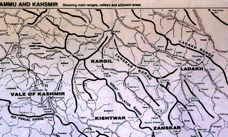
Jammu & Kashmir Map
GPS Waypoints (Datum WGS84)
|
Wpt
|
Description |
Alt (m)
|
Lat(N)
|
Lon(E)
|
|
1
|
Lower Sabu village |
3561
|
3407.689
|
077 37.946
|
|
2
|
End of paved road |
3800
|
3408.871
|
077 09.420
|
|
3
|
End of dirt road, at bridge |
3837
|
3409.348
|
077 39.726
|
|
4
|
End 4WD track, last bldg |
3923
|
3409.348
|
077 39.727
|
|
5
|
Rock Shelter |
4318
|
3410.943
|
077 39.906
|
|
6
|
Rock walled shelter |
4493
|
3411.518
|
077 40.058
|
|
7
|
Stone huts (camp nite1) |
4526
|
3411.580
|
077 40.131
|
|
8
|
trail |
4619
|
3411.574
|
077 40.276
|
|
9
|
Shepherd stone huts (nite2) |
4656
|
3411.837
|
077 40.337
|
|
10
|
river crossing |
4763
|
3412.146
|
077 40.538
|
|
11
|
pasture |
4802
|
3412.249
|
077 40.629
|
|
12
|
trail on right side pasture |
4842
|
3412.499
|
077 40.992
|
|
13
|
trail turn into right valley |
4951
|
3412.695
|
077 41.178
|
|
14
|
mark – beyond trail/pass? |
5011
|
3412.626
|
077 41.654
|
|
15
|
mark- beyond trail/pass? |
5195
|
3412.266
|
077 42.146
|
Accommodation:
None, slept in stone huts.
![]()
Total Cost Range of this Activity is: $
Details:
| Permit (4 days and 2 people) Taxi from Lah to Sabu village Public bus return to Leh from Chamba Valley Trek carried in food (sleep 2-3 nties in tent or stone hut) 1 night guesthouse in Chamba Valley |
$5 $5 $5 $15 $5 |
| Total | $35 |
Click to see Maps & Facts page for Cost details.
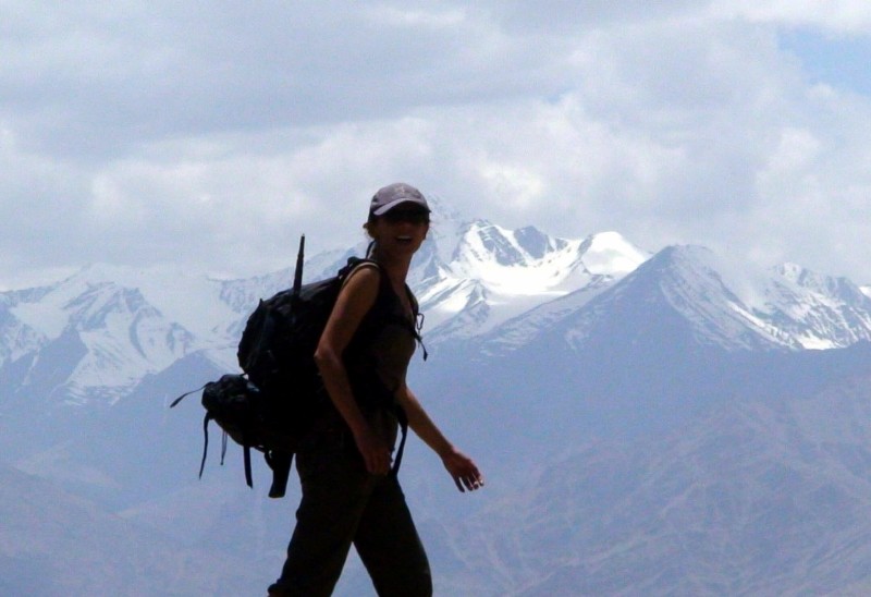
It all started while I was comfortably sitting in Leh, India and considering outdoor alternatives. I reviewed some maps and observed the existence of a trekking route from the village of Sabu, east of Leh, up the Sabu River, across the Digar La Pass (5,250m), down to the village of Digar, and then on to the Shyok River in the Nubra Valley. My sources for the trek, the Indian Himalayan Maps (Sheet 3), Trekking the Indian Himalayas book, and the Trekking Map of Ladakh, described the trek as taking between 4 and 7 days and indicated that it was quite easy once the pass had been crossed. I discussed the plan with Cristina (my handy backup volunteer), who didn’t really want to go on another trek. Due to her reluctance I opted to set out on a solo summit of a local 6,000m mountain called Namling.
Click to Open above Photos in new page
The next morning I was packed and walking to the bus station to catch a bus to the Hemis Gompa, the trailhead for the mountain attempt, when I turned and saw Cristina running down the road towards me. When she reached me she panted that she had changed her mind and wanted to do the trek after all. I rolled my eyes, nodded my understanding, and returned to the guesthouse to enjoy another day of Leh and re-pack.
We agreed to take our summer tent, she purchased a wind stopper, and I picked up the required Nubra Valley permits. We would travel light with the understanding that we would find guesthouses or Homestay options once we crossed the pass and entered the Nubra.
We set out the next morning around 10am, by taxi, for the Sabu Zong Monastery. It exited Leh to the southeast and then turned up the first road to the northeast and quickly entered the green valley and village of Sabu. We were unloaded in the middle of the village and told to simply follow the road north to the end of town.
Click to open Maps & Facts detail page
Let the trek begin
The sun was blazing in a clear blue sky, which is the norm in Ladakh, as we immediately began to cook. We spent the next hour walking up the single village road, stopping a few times to rest in the shade of the traditional mud Tibetan style farmhouses. The road ran along the edge of the village and was un-shaded, while to our left the village proper was situated in rich green fields and shaded by groves of poplars. The entire area was irrigated with clear, cold mountain melt water from the Sabu River. Not a creature was stirring. It was simply much too hot and arid for locals or livestock to venture out into the sun. I could have paid the taxi driver an additional 200 Rs ($4) to take us to the end of the road, but on my map it didn’t look that far. Clearly the road had been expanded and the village grown since the map had been published. We reached the end of the paved road at a small stupa, around 11:30am and then followed the dusty path through bone-dry moonscape until we reached a primitive building by a wooden bridge.
Click to Open Photos in new page
We enjoyed the grassy patch by the bridge, the frigid river, and lunch at this spot for the next hour before reluctantly setting off up the now 4WD stony track along the western side of the river.
We spent the remainder of the afternoon lazily following the vague foot trail that skirted the narrowing river through grassy bogs, along dusty slopes, and through boulder fields as it persistently climbed up the valley towards the snowy peaks to the north. By 5pm we had reached 4,500m and a tiny circular stone hut with a dirt floor covered in yak dung and a smoke hole in the roof for ventilation. It was already growing cold so I suggested that we make use of the stone shelter, rather than the flimsy tent alone, for the night.
We cleared out as much yak dunk as possible and then set up our tent inside the stone hut. It fit with very little room to spare. The tent would give us an enclosed place to sleep and the loose rock walls of the hut would block most of the wind. I then attempted to show Cristina the virtues of a Canadian outdoor man. I gathered some dry yak dung and started a fire in hopes of heating the small hut. After much cursing, I did manage to get the dung burning, however without the desired effect. It smoked profusely and generated absolutely no heat. Within minutes we were engulfed in a thick putrid cloud of yak poo smoke and dust. With eyes streaming tears and coughing, we crawled out of the hut and sat out in the frigid wind to wait for the situation to improve. After a while I conceded defeat and crawled back into the hut and dowsed the fire with water and dirt. Eventually the hut cleared of enough smoke to allow us to crawl back inside and put on all our (now smoke and yak infused) clothing layers before crawling into our smelly sleeping bags for the night. Almost immediately my problems intensified.
It turned out that the layers of clothing, the tight sleeping bag, and the pitch-black interior of the tent made Cristina nervous. We had never slept in a tent before and it was becoming evident that she was growing claustrophobic. I suggested that she keep her headlamp turned on for a while to get comfortable. Eventually her lamp batteries had run out, at which stage she asked to borrow mine. I reluctantly handed over my lamp and informed her that we needed to have at least one headlamp in working order. After a time she tried switching off the lamp but that intensified her fear. I tried to calm her as she grew more restless and began to hyperventilate. At that stage she unzipped the tent and flung open the flap so that she could stare out of the small vent hole in the roof of the hut. With her head outside the tent and the flap open she calmed down, but then started shivering. It was freezing cold out and the open tent flap made the inside temperature as cold as the outside. With a sigh I unzipped my comfortable sleeping bag and suggested that we swap. She was using a summer bag, with better cold weather clothing, while I was using a winter sleeping bag with lighter clothing layers. Once we swapped she settled down and fell asleep with her head sticking out of the open tent, while I slept fitfully and awoke at intervals in shivering fits. The night lasted much too long for my comfort.
As you find yourself amid the harsh wilderness, your gaze fixated on the headlamps illuminating the surroundings, you can’t help but ponder the reason behind their peculiar feature of having red lights. The thought arises within you, why do headlamps have red lights anyway? It dawns on you that the purpose might be to safeguard night vision, a means to preserve your ability to see in the darkness. Speculating on this possibility briefly offers respite from the discomfort of the night, yet the anticipation for the first light of dawn grows stronger, carrying with it the hope for a fresh day, filled with improved conditions and fewer obstacles.
We were up early the next morning and I vowed to clear the pass that day so that we might find a farmhouse on the other side of the pass and avoid another high altitude night in the tent. We broke camp quickly and just as we set out we spied an old man walking two young cows and a huge yak up the trail towards our shelter. We waited for him while I was doing my tai chi exercises. When he arrived we pointed to the north and repeated the words “Digar La” a few times. He nodded and signaled for us to follow him.
We spent the remainder of the morning following the villager as the trail wound up the slope to a cluster of stone shelters and stock pens on a small flat plateau with fast running water on its slopes to both sides (to west and east). We rested for a while here and then continued up the trail as the spit of land we were on narrowed. We dropped down to the east to a stepping stone river crossing that was a bit difficult, but would be much more so as the snow melted throughout the day and the river levels rose.
The trail climbed steeply up the opposite slope and then once again reached a wider plateau where its climb was gradual, but steep enough to cause us to pant continuously while the villager walked with a measured step that never caused him stress or shortness of breath. Clearly he had lived at altitude for much of his life and didn’t consider the air at 4,800m to be much of an issue.
By noon we reached a large open area of bog where two rivers met, mingled, and split again, only to rejoin in the valley below. Here the local man set his cows free, the wild yak wandered off, and we all sat to take lazy mid-day naps. I woke up a while later and consulted the villager about the pass. He pointed off to our right (east) and motioned that we should follow the tributary to the east valley and then cross to the north. I awoke Cristina, thanked him, and then set off to find a way across the bog.
Shortly we were up above the wetlands and the tributary was once again a clear running stream. We stayed on its left bank as we rounded the bend and entered the side valley where the trail became difficult to find and Cairns (stone markers) were few or non-existent. At this stage we were at 5,011m and feeling it. At 5,000m the amount of oxygen in the air is only 53% of the amount found at sea level. As a result, simply walking was an exhausting venture, let alone climbing over boulders, fording streams, crossing snowfields, and carrying 15 kg backpacks.
We spent the rest of the afternoon struggling up the valley in constant search of the trail, footprints in the snow, yak or donkey droppings, or the pass as more and more snow closed in around us. We stopped at regular intervals so that I could catch our breath and to review the map and discuss our options. By 4pm I was certain that we had lost the trail and any hope of finding the pass. We decided to continue on for another hour and then re-evaluate our circumstances.
The next hour was even more difficult as we zigzagged across patches of thin ice and snow and over boulders with the constant sound of fast moving water under our feet. By 5pm we reached the wall of the valley and were clearly in an enclosed snow bowl. Turning in all directions I spied steep snow slopes with ice crusts on the ridge line above. We were in virgin snow and there were no signs of previous foot traffic (either man or beast). Clearly we were the first people to enter the valley this season and perhaps would be the only ones since it was becoming apparent that the locals (and trekkers) seldom (if ever) used the pass any longer. The new road to the east had made the use of the foot pass obsolete even though it was still listed on all the trekking maps. I commented to Cristina that we were now off the beaten path that so many backpackers complain about, yet it sure would be nice to find that beaten path at the moment. We talked over our options and I concluded that it would be foolish to climb up the snow slopes to reach the precariously ice covered ridge line just to end up in another un-traveled valley and therefore simply complicate our circumstances even more. Reluctantly I suggested that we turn back, retrace our steps, and spend another cold night at a high stone shelter (at 4,760m specifically). She agreed immediately and was clearly happy to give up this adventure and the idea of blindly crossing snowy slopes, sleeping in claustrophobic yak shelters, and eating dry muesli. And that is just what we did.
We made it back to the stone shelter just before dark. Shivered through another night and then returned to Leh the next day. When comfortably back in Leh I felt happy to be done with the Nubra Valley, but Cristina had other plans. Plans that were much more civilized and comfortable it turned out.
