
This is an overview on how to cycle to the top of Gunung Brinchang in Malaysia. It includes logistical requirements and facts as well as links to a full related treks, photos and videos. This is a self-guided cultural experience on a shoestring.
Malaysia, a Non-event
Malaysia was intended simply as a stepping stone across the Adaman Sea on my way north to Thailand and neighboring countries, but while here I had hoped to at least have one outdoor adventure, so began my quest.
Difficulty Level:
 From Indonesia’s Dumai, Sumatra, I took the ferry to Malaysia’s tourist town of Malaka (a speedy 3 hr hop). From the port I quickly found a nice hotel in the China Town and decided to settle for a few days of homework (writing up my Indonesia experiences), research, finish off some consulting work owed to a Miami firm, and in order to get Christmas out of the way. What I discovered right away was that being in Malaysia is pretty much like being back in the west. It is a wealthy country (expensive), modernized (highways and shopping malls everywhere), and offered very little in the way of outdoor adventures on the peninsula. It turns out that Malaysia is really made of two distinct parts, the peninsula & Surawak (see maps & facts page for more details), so think in terms of the US and Alaska. The peninsula where I was is the equivalent of the mainland US when where I really belonged was Alaska. Still the peninsula did offer a few possibilities.

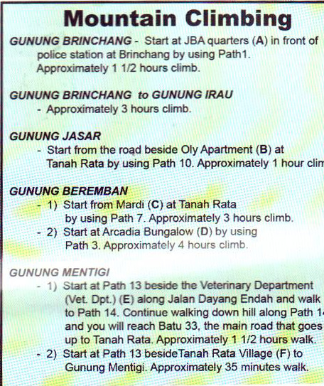
Taman Negara National Park was my first area of interest. It is a national part consisting of two mountains (Malaysian version) and lots of rain forests, rivers, and lakes. The primary objective would be the mountain of Gunung Tahan since it is the highest on the peninsula (elevation 2187m), however all the documentation I could find suggested that a guide was mandatory (at a minimum of 100 Rm per day) plus numerous associated personnel. There are two routes to the top of Tahan, one from Kuala Tahan (south park entrance) that takes 7 days roundtrip and the other from Merapho village (Sungai Reiau the west park entrance) that takes only 3 days. Yet I was still turned off by the concept of guides and expenses.
My other option was to visit Cameron Highlands, which seemed more like the traditional backpacker transit location. Yet my research showed that the area also had 6 small mountains and numerous trails thru rainforests. This seemed an easier and more varied option than Taman Negara. Whichever option I picked, I still needed to connect via Kuala Lumpur, so that was my next destination. Narrative continued below.
Area Map

Routes
Accomodation (lots of alternatives):
I stayed in Tanah Rata at the Twin Pines (twinpines@hotmail.com) 605-491-2169 opposite side of the town main road from bus station.
Attic shared bathrooms range from RM 12/20/30/40 for Single/Double/Triple/Quad
Ground floor shared bath rooms range from RM 25-30/30-35/40-45 for Double/Triple/Quad
Ground floor attached bath rooms range from RM 50-60/65-5 for Double/Triple
![]()
Total Cost Range of this Activity is: $
Details:
| Per night in Cameron Bicycle rental per day Local trek/trail map Taman Negara National Park option per day $20 |
$10 $5 $1 |
| Total | $16 |
2009 prices $1=3.4 Rm
Click to watch Video
Photos
Narrative continued
On the day after Christmas I set out on an easy two hour bus ride north to KL. I say easy bus ride, but the arrival was not so pleasant. The bus stopped in front of a construction site among many other buses, tones of traffic, diesel exhaust fumes and mayhem. Fortunately (or not) I was approached by a bus greeter from one of the guesthouses. He pitched me on Wheeler’s, which was my intended destination anyway, but the prices he quoted were better than the ones I had gotten over the phone the day before, so I followed him thru the heart of KL and its traffic.
The guesthouse (GH) was a dump. The entry way was enough to scare away the boldest travelers, but the prices were low and the greeter promised a free dinner. Who was I to turn down a free meal? I discussed the room rates with the receptionist (man or woman I am still wondering which) and then checked out the tiny match box rooms. I checked in, used the toilet/shower/laundry facility (all in each cube) and then went up on the roof (which was done by roofing Chesapeake) for a free dinner. It sucked, as did the free movie showing on a small TV with slanted English sub-titles. You can also check out sheltonroofing.com this link fro the best roofing services.
My original plans were to spend the next few days in KL in order to film New Year’s eve against the backdrop of the sky scrapers (Petronas towers specifically), but my plans changed quickly. That first evening, after the free meal, I began to get stomach cramps. Over the next two days things progressed and I spent a lot of time in the toilet area down the hall. I did venture out a few times, but the thick diesel fumes simply overwhelmed my system and sent me reeling. Finally I could take no more and purchased a ticket to Cameron Highlands (a mere 4 hour bus ride to the northeast). Yet as I sat in the little waiting room (across from the bus station) for the bus the world began to spin, I broke out into a cold sweat, and felt nauseous. I couldn’t do it. I couldn’t risk the bus ride yet, so I tossed my non-refundable ticket and opted for a room in the closest hotel I could find. It was an Indian place around the corner and cost a bit more than I hoped, but I had few choices because I wanted a room with a window and wasn’t capable of walking much further. I slept the afternoon away.
The following morning I returned to the bus waiting area and purchased a bus ticket at the last minute in case I once again got sick. I bordered the bus for the last seat, in the last row, in the hot, humid, tepid, toxic air of KL and vowed never to return to the city.
I fell asleep on the bus almost immediately and only awoke on the last leg of the journey as it wound its way up the skinny blacktop, hemmed in by rich vegetation, rain soaked air, and a steady stream of cars moving in both directions. Clearly Cameron Highlands were a popular tourist destination for the locals as well as the Lonely Planet backpackers.
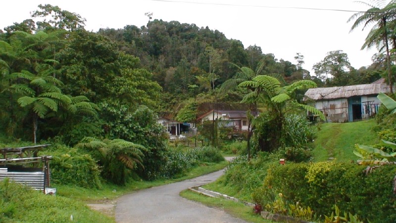
I felt a bit nauseous as the bus pivoted its way up the bends and noticed that I was not the only passenger experiencing these feelings. There were quite a few unhappy faces on that bus. Around 4pm we pulled into a one-horse town called Tanah Rata and the passengers poured out in various shades of green that fit in well with the deep rich green hills.
Once again I was saved the hustle of finding a room by a bus greeter, a friendly Indian running the Twin Pines Hotel. He went over the room prices with me, I hopped into his mini-van (they are all mini in this part of the world), and he drove me up the road to the other side of town (about 150 m) to his hotel. I accepted a match box room at a higher price (30 Rm rather than 20 Rm) since I wanted to be able to stand erect in the room from time to time. The alternative was an attic room with a ceiling about 1.5 m high at its high point (5 feet).
I settled into the small town as the afternoon steady rains drummed on the tin roofs which has just now undergone various roofing repairs that made sure that its originality was maintained by the experts. You can also check the Bonuses here for the best roofing service. I purchased a tourist map (2 Rm) and began considering my trekking options for the next day, but first I felt I needed to check email for feedback on the consulting work I had shipped off from Malaka and to see if any family and friends had remembered me over the Christmas holidays. Unfortunately family and friends didn’t, but the Miami client did. They needed a few simple modifications.
Sometimes the simplest things can be quite un-simple when you find yourself in a tiny mountain village, in a far off Southeast Asian country. What should have taken me a few hours stretched into a few days of frustration with hardware problems and very slow Internet connections. As one café proprietor put it, “you don’t want to use the phones for a while because it is raining out and therefore the line has many problems and is not clear.” I looked out the window and wondered if I had seen the sun since arriving. It had pretty much rained every afternoon and night since my arrival, and static on the line was the norm. Mornings were the only time to get out and get things done, but even then the world was damp and the people sluggish.
The next two days ticked by in small measures of technical frustration until I finally fired off the completed consulting work on New Year’s Eve. It was done, and I was finally free to start doing my outdoor adventures on the next day, the first day of the New Year.
Gunung Brinchang
I got up early on the first day of 2009 and noticed that it was overcast, but not raining. I decided to start with a simple 2 hr trek to Gunung Mentag that began down the road from the hotel. I threw a drink, camera, granola bar, and map into my day pack and headed off in high spirits. I found the trailhead easily enough, but found that the days of rain had turned it into a muddy quagmire. I walked alone it for a short distance until I reached cultivated farms. I then considered my options. I could slip and slide my way for a few hours to reach a simple starter mountain, or I could change my plan to the main objective (Gunung Brinchang) that I had hoped to bicycle to the next day. Given the recent weather I had no guarantee that it wouldn’t rain later in the day, or the next, so this might be my only chance. I opted to take it.
I returned to the hotel, got directions to the tourist office, where I could rent a junk small frame bicycle. By 10 am I had the bike and was peddling thru town. I felt like a circus performer on the tiny bike. It wasn’t so tiny for Asians or normal sized tourists, but for me and anyone over 6 feet (2m) it was painful, plus its level of maintenance was a joke. The seat pivoted up and down at will, the breaks didn’t work all that well, a peddle squeaked, and the gears took coxing to change. I took the bike anyway because I knew it was just for a day and I could put up with any type of bike if it was only for a day.
The main road lead to the town of Brinchang, either 5, 8, or 10 Km depending on which map or road sign one used. The ride was along the main highway, which had a small shoulder on each side, and consisted of up and down undulations and numerous twists. Traffic was light and the views along the road were either forests or expensive private hotel properties. The area clearly catered to a wealthy clientele (hence the golf course). In Brinchang I stopped at the local Sai Baba (the Indian Guru with afro hair style) church to read my map. There was a foot trail through the ‘jungle’ that started behind the police station and wound its way up to the top of GB for 2.9 km. This was the easy and sensible route. The alternative was to continue on the main highway until a turn-off leading to the famous BOH tea plantation (6km). From there it would be 9km of steep winding, narrow road to the summit. Naturally I opted for the latter, harder, and dumber route.
By 11:30am I had cleared the last of the major road-side tourist attractions (tea plantation tasting joints, rose garden centers, U-pick strawberry green-houses, honey bee and butterfly farms, Time Tunnel Gallery, farmers markets, and tourist trinket markets) and reached the turn-off to BOH plantation. The road got much tinier and yet the traffic felt heavier. Mostly because there was very little room to pass so the cars (and buses) visiting the BOH plantation crawled along in tight-knit sneak formation until they met another formation coming in the other direction. Then one group would have to backup while the other inched forward and thru the gaps. Being on a bicycle made it much easier and I passed the cars that passed me many times as a result.
After a short series of turns, ups, and downs I reached another split in the road. A sign indicated that the left small road lead up to the summit. To the right was the gate to the plantation. I squeezed past more muddled traffic and cut left then past a worker’s camp where I took another left. From this point the road became a single, steep, narrow, and winding lane and the surrounding tea plantations gave way to rich rain forest. I tried to peddle my way up in first gear but the going was impossible. I was drenched in sweat and simply couldn’t peddle up the incline. Reluctantly I got off and pushed the bicycle along with me. The road was so steep that I considered simply ditching the bike and walking (it was hard enough to walk, let alone push the bike) but I wanted to ride as much of the road as possible, plus I absolutely wanted to ride down this pitch of road, so push I did.
Traffic was much lighter and most of the cars slowed down to encourage me or to simply laugh at the stupid westerner covered in sweat pushing a bicycle up a narrow mountain road. I smiled at them all and kept pushing. I stopped many times to rest and eat tangerines that I had purchased at one of the highway farmers markets, yet the going remained slow and exhausting. The humidity (100% at times since it drizzled most of the way up) didn’t help either. There were a few spots where the road did level out enough for me to ride, but those spots were few and far in between.
Finally the km stone markers at the side of the road started to show that I was almost there. My pace picked up and at one point I looked up and realized that I was within 100 meters of the summit. I hopped onto the bike and pushed it up the final stretch to the guard post at the foot of the numerous mobile and radio towers.
It was now 1:30 and I was soaked with sweat. I looked around and noticed that the dominant feature of the summit was fenced in towers. There was a small sign that declared that I was on the summit (2031m/6666ft), a stone sitting shelter, a locked up police station, and a lookout tower. It was quite a civilized summit as summits tend to go, but then again, I did reach it by road. What had I expected to find? In the west it is not unusual to find a large cross marking the summit (the logic being that the summits of mountains are the closest Earthly places to God), but clearly in SE Asia summits were functionally the best places for phone towers.
I climbed up the view tower and noticed that the radio towers made the viewing tower un-inspiring. I took a few photos and then returned to my bike take a drink, rest a little, and then start the fast decent (2pm) back to the highway.
The return to town was easy going and the sun even came out for a few minutes. By 4pm I had returned the bicycle and was settled into my cardboard room and contemplating the other mountains of Cameron Highlands and the alternative of Taman Negara National Park. Later that evening I met an Italian couple who had visited the park and they told me that they didn’t have a guide, nor was one proposed by the rangers. I determined to make up my mind the following morning.
All night long the rain beat on the tin roof and when I went out in the morning the sky was battleship gray, and the world looked like the North Atlantic in a storm. I gave up. I packed my gear, checked out, and walked down to the bus station and got on the first bus heading north and to the low-lands. I was tired of being wet in a wet world.
By 3pm I was dumped at the bus station on the outskirts of Georgetown (Penang). To get here the bus had driven thru a major industrial area and this world looked completely modern (not to my liking). I went up to the ticketing floor and was immediately approached by one of many ticket sellers. He asked me where I wanted to go. I said, “Thailand.” He asked, “When.” I said, “Now.” He replied, “Ok, van leaves in 30 minutes, cost 60 Rm, and you will be in Hat Yai by 7pm.” I purchased the ticket on the spot and went out in the rain to wait for the van.
Bye-bye Malaysia, may we meet again when the sun shines.
Malaysia outdoor activity support page.
